The Corangamite Regional Catchment Strategy (RCS) identifies the priorities for integrated catchment management across the region for the six years from its implementation until it is updated. A collaborative and adaptive approach, applying best available information, integrated catchment management principles and delivering at a local scale to contribute to regional, state and national natural resource outcomes is at the core of the implementation.
The desire for the strategy to “be a reference for useful information” is provided through its online format. This format provides the opportunity to enable links to relevant information being incorporated within its layout under various sections. The ability to link to the Natural Resource Management Portal and the CCMA Knowledge Base also provides users with a pathway to find information to make natural resource management decisions at a scale relevant to their needs.
The RCS is delivered through a partnership with both public and private land managers, agency stakeholders, and the whole community. Project development and delivery will be coordinated through partner organisations, Landcare networks and industry groups. Delivery complies with all relevant regulations utilising best management practice methodologies derived from the best science and latest thinking.
Implementation of the RCS
Regional Implementation is based on using the participation principles that guided the RCS renewal:
- Plan how outcomes and priority directions will be achieved
- Identify and establish partnerships for collaborative delivery
- Develop a timeline for implementation
- Establish a detailed monitoring and evaluation framework that enables for adaptive management of the implementation process and transparency of delivery.
This table lists the progress of projects that are contributing to the delivery of the RCS. It covers the time period from the launch of the RCS in March 2022. Only projects for which reports have been received have been included.
| Project name | Organisation | Theme(s) | Project description | Regional priority direction | Progress | Link to project | |
| 1 | Protecting Priority Threatened Species of Corangamite Coast | CCMA | Biodiversity | The Orange-bellied Parrot Protection program focuses on the protection of the critically endangered bird and supporting future opportunities for increasing and stabilising their population | B18 -Implement an additional 20,000 hectares of sustained predator control (not year by year cumulative total) in priority locations as defined by Biodiversity Response Plans and other regional plans | Completed | Link to map |
| 2 | Improving On-Farm Soil, Vegetation for Larger Agricultural Enterprises | CCMA | Land | A partnership between the Corangamite CMA, Agriculture Victoria, WestVic Dairy, and Landcare will lead the Sustainable Dairy Management Project to engage dairy communities to support whole of farm nutrient management in the Gellibrand and Curdies River catchment | L2 – Best land management practice approaches are implemented across farmers, agencies, developers, and the catchment community | Completed | Link to map |
| 3 | Protecting the Victorian Volcanic Plains | CCMA | Biodiversity | Delivery on a landscape scale using established partnerships and knowledge to deliver, across public and private land, improved land management practices across the Victorian Volcanic Plain (VVP) | B10 – Develop partnership agreements that enable best management practices and standards for managing the region’s natural habitats and the flora and fauna that they support. | Completed | Link to map |
| 4 | The Australian Government’s Wild Otways Initiative | CCMA | Biodiversity | The Australian Government’s Wild Otways Initiative is a three-year $6M commitment to achieving on ground outcomes that will improve the protection and management of threatened species in the Otways, Victoria | B12 – Within the region, develop actions to deliver an overall net gain of ‘Suitable Habitat’ for focal species by 2027. | Completed | Link to map |
| 5 | Dunecare-Protecting Sand Dunes on Surf Coast, Bellarine, Great Ocean Road | CCMA | Biodiversity | M2 – Build research and knowledge, including Traditional Owner knowledge of coastal / marine systems and threatening processes to inform adaptive management and mitigation. | Completed | Link to map | |
| 6 | Small blocks, big dreams: Engaging peri-urban landholders in best practice integrated catchment management | CCMA | Land | Will engage new peri-urban landholders in catchment management and empower them to adopt environmental best practices through a tailored farm planning program | L8 – Support farmers with information and tools to build resilience. | Completed | Link to map |
| 7 | The Living Moorabool Flagship Project | CCMA | Water | The Living Moorabool Flagship is a series of projects that all aim to improve the health of the Moorabool River downstream of the Lal Lal Reservoir, and the West Branch of Sutherland Creek | W5 – Deliver waterway health programs identified in the Corangamite Waterway Strategy using an integrated catchment management approach | 50 – 75% Completed | Link to map |
| 8 | Upper Barwon Flagship Project | CCMA | Water | CCMA has identified the Upper Barwon River as the focus for investment as part of the EC5 Flagship Waterways project | W5 – Deliver waterway health programs identified in the Corangamite Waterway Strategy using an integrated catchment management approach | 75 – 100% Completed | Link to map |
| 9 | City to Sea – Lower Barwon River and Barwon Wetlands | CCMA | Water | Will deliver an integrated management program for the Bellarine Landscape Zone | W5 – Deliver waterway health programs identified in the Corangamite Waterway Strategy using an integrated catchment management approach | 75% – 100% Completed | Link to map |
| 10 | Rivers of Gold and Western District Lakes | CCMA | Water | Builds on existing Ramsar, waterway protection and citizen science programs in the Western District Lakes and surrounding catchment | C10 – Promote and actively encourage the use of citizen science information by agencies, researchers and other members of the community. | 75% – 100% Completed | Link to map |
| 11 | Delivering integrated catchment management for the Gellibrand | CCMA | Water | Will maintain existing activities in the Gellibrand River and estuary and develop an integrated catchment management plan for the catchment | W5 – Deliver waterway health programs identified in the Corangamite Waterway Strategy using an integrated catchment management approach | 50 – 75% Completed | Link to map |
| 12 | Surf Coast and Otways Restoration | CCMA | Water | Will improve estuary and river health outcomes in the Otway Coast Basin | W5 – Deliver waterway health programs identified in the Corangamite Waterway Strategy using an integrated catchment management approach | 75% – 100% Completed | Link to map |
| 13 | Curdies Estuary Fish Habitat Restoration Project | CCMA | Biodiversity | The Curdies River and Estuary is a destination waterway for angling species such as Black Bream and Estuary Perch in SW Victoria. The performance of recreational fisheries is consistent, through limited by lack of instream woody fish habitat | B12 – Within the region, develop actions to deliver an overall net gain of ‘Suitable Habitat’ for focal species by 2027. | Completed | Link to map |
| 14 | Barwon Estuary Fish Habitat Restoration Project | CCMA | Biodiversity | The Barwon River and Estuary is at the heart of burgeoning Geelong and is popular for fishing, paddling and rowing. The performance of recreational fisheries is held back by limited instream woody fish habitat and low abundance of angling species | Within the region, develop actions to deliver an overall net gain of ‘Suitable Habitat’ for focal species by 2027. | Completed | Link to map |
| 15 | Barwon Flagship Part C – Enhancing Cultural & Waterway Amenity Values in the Mid Barwon | CCMA | Water | Restoration works along the Barwon River and Leigh Rivers and tributaries that flow in from Teesdale, Bannockburn and Shelford to Inverleigh | W5 – Deliver waterway health programs identified in the Corangamite Waterway Strategy using an integrated catchment management approach | 50 – 75% Completed | Link to map |
| 16 | Kitjarra-dja-bul bullarto langi-ut (Barwon River Parklands) Masterplan and Implementation | CCMA | Community | The project will develop and partially implement a masterplan for the Kitjarra-dja-bul bullarto langi-ut (Barwon River Parklands) | W8 – Protect and enhance areas of riparian vegetation along priority waterways as defined in the Corangamite Waterway Strategy including fencing to reduce the impact of livestock. | Completed | Link to map |
| 17 | Water-Salt Balance Model for the Lower Barwon Wetlands | CCMA | Water | Computer Source model the Lower Barwon Wetlands focused on salt balance | M2 – Build research and knowledge, including Traditional Owner knowledge of coastal / marine systems and threatening processes to inform adaptive management and mitigation. | Completed | |
| 18 | Yarrowee River Stabilisation Project | CHW | Water | Central Highlands Water (CHW) and its project partners City of Ballarat, Corangamite CMA and Wadawurrung Traditional Owners implemented the construction of river bank stabilisation works in the Yarrowee River adjacent to the Ballarat South | W2 – Catchment partners and the community collaborate to deliver a coordinated approach to water management with clear roles and responsibilities communicated | Completed | |
| 19 | Enhancement of wetland areas at White Swan and Gong Gong Reservoirs | CHW | Water | An annual weed control program is implemented at the CCMA wetland priorities areas at White Swan Reservoir | W8 – Protect and enhance areas of riparian vegetation along priority waterways as defined in the Corangamite Waterway Strategy including fencing to reduce the impact of livestock. | 25 – 50% Completed | |
| 20 | Enhancement of wetland areas at White Swan and Gong Gong Reservoirs | CHW | Water | An annual weed control program is implemented at the CCMA wetland priorities areas at and Gong Gong Reservoir. | W8 – Protect and enhance areas of riparian vegetation along priority waterways as defined in the Corangamite Waterway Strategy including fencing to reduce the impact of livestock. | 25 – 50% Completed | |
| 21 | Waterwatch | CHW | Community | Partner with CCMA WaterWatch team to deliver National Water Week activities aligned to the Victorian Curriculum | C2 – Ensure community education and engagement activities are grounded in the most recent and relevant social research available, and targeted to the specific local geographic area. | Completed | |
| 22 | Education Program – newsletters | CHW | Community | Liaise and collaborate with teachers in our service region to ensure education programs are relevant and reach their goals | C4 – Design and deliver a comprehensive education program to connect communities (local, new and visitor) to their local landscape and the enviromental services it provides and empower them to take action. | Completed | |
| 23 | River Detectives | CHW | Community | Liaise and collaborate with teachers in our service region to ensure education programs are relevant and reach their goals | C4 – Design and deliver a comprehensive education program to connect communities (local, new and visitor) to their local landscape and the enviromental services it provides and empower them to take action | Completed | |
| 24 | CHW annual weed control program | CHW | Water | Priority areas sprayed for weeds in 2022-23 | W8 – Protect and enhance areas of riparian vegetation along priority waterways as defined in the Corangamite Waterway Strategy including fencing to reduce the impact of livestock. | Completed | |
| 25 | Weed control at Wilsons and Moorabool Reservoirs | CHW | Water | Priority CCMA wetlands – Wilsons Reservoir, Moorabool Reservoir | W2 – Catchment partners and the community collaborate to deliver a coordinated approach to water management with clear roles and responsibilities communicated | 25 – 50% Completed | |
| 26 | Weed control at the headwaters of Lal Lal Creek. | CHW | Water | Priority CCMA Waterways Mooraboool River West Branch, Lal Lal Creek, Spring Creek. | W2 – Catchment partners and the community collaborate to deliver a coordinated approach to water management with clear roles and responsibilities communicated | 25 – 50% Completed | |
| 27 | Weed control at the headwaters of the Moorabool River West Branch. | CHW | Water | Mollongghip Reserve, Wobblers Reserve, Top Moorabool Reserve, Moorabool Middle Reserve Weed control. | W2 – Catchment partners and the community collaborate to deliver a coordinated approach to water management with clear roles and responsibilities communicated | 25 – 50% Completed | |
| 28 | Urban Water Strategy Implementation | WW | Water | Wannon Water section of the Corangamite CMA Region | W2 – Catchment partners and the community collaborate to deliver a coordinated approach to water management with clear roles and responsibilities communicated. | 75 – 100 % Completed | |
| 29 | Coordination, guidance and advice on water quality | WW | Water | Wannon Water section of the Corangamite CMA Region | W1 -Develop and implement a monitoring and evaluation framework that enables timely adaptive management and decision making. | 75 – 100 % Completed | |
| 30 | Leading the Water Smart water efficiency campaign | WW | Water | Wannon Water section of the Corangamite CMA Region | W3 – Explore and implement cost effective water efficiency measures including demand reduction initiatives and alternative water sources. | 75 – 100 % Completed | |
| 31 | Lead and participate in projects that lead to an improvement in catchment health | WW | Water | Gellibrand Catchment within the Otway Coast Landscape System | W5 – Deliver waterway health programs identified in the Corangamite Waterway Strategy using an integrated catchment management approach. | 75 – 100 % Completed | |
| 32 | Implement Barwon Water’s “Boundary Creek, Big Swamp and Surrounding Environment – Remediation and Environmental Protection Plan” | BW | Water | Barwon Plain Landscape System | W11 – Ensure the impact of groundwater extraction on Groundwater Dependent Ecosystems (GDEs) is monitored, assessed and taken into account in decisions on applications for new or transfers of groundwater entitlements. | 75 – 100% Completed | |
| 33 | Implementation of Barwon Water Urban Water Strategy | BW | Water | Barwon Water section of the Corangamite CMA Region | W3 – Explore and implement cost effective water efficiency measures including demand reduction initiatives and alternative water sources. | 75 – 100% Completed | |
| 34 | Drinking Water Catchment Protection | BW | Water | Barwon Water section of the Corangamite CMA Region | W2 – Catchment partners and the community collaborate to deliver a coordinated approach to water management with clear roles and responsibilities communicated. | 75 – 100% Completed | |
| 35 | Implementation of Urban Water Strategies and Sustainable Water Strategies via working group | CHW | Water | Progress implementation of CHW Urban Water Strategy 2022 actions and priority projects identified by CHW Integrated Mgt Forum and Central and Gippsland SWS | W3 – Explore and implement cost effective water efficiency measures including demand reduction initiatives and alternative water sources by implementing the relevant plans and strategies | 25 – 50% Completed | |
| 36 | River Detectives (2024-2028) | CCMA | Community | Liaise and collaborate with teachers in our service region to ensure education programs are relevant and reach their goals | C4 – Design and deliver a comprehensive education program to connect communities (local, new and visitor) to their local landscape and the enviromental services it provides and empower them to take action | 0 – 25% Completed | |
| 37 | Corangamite CMA and Barwon Water Waterway Protection Program Partnership (2024-2028) | CCMA | Water | Addressing landslip threatening a BW offtake with remaining funding directed to other geomorphology issues that will contribute to progression of the Barwon Flagship project and outcomes for environmental watering | W8 – Protect and enhance areas of riparian vegetation along priority waterways as defined in the Corangamite Waterway Strategy including fencing to reduce the impact of livestock | 0 – 25% Completed | |
| 38 | Curdies River Riparian Works | CCMA | Water | W8 – Protect and enhance areas of riparian vegetation along priority waterways as defined in the Corangamite Waterway Strategy including fencing to reduce the impact of livestock | 75 – 100% Completed | ||
| 39 | Karrkiyn Warbulloc (Lava Stone Plain) | CCMA | Biodiversity | Will implement actions to manage and restore the Natural Temperate Grassland of the Victorian Volcanic Plain ecological community consistent with approved conservation advice. It will also provide benefits to the Grassy Eucalypt Woodland of the Victorian Volcanic Plains ecological community, the Plains Wanderer (Pedionomus torquatus) and the Grassland Earless Dragon (Tympanocryptis pinguicolla), consistent with approved conservation advice and recovery plan | B12 – Within the region, develop actions to deliver an overall net gain of ‘Suitable Habitat’ for focal species by 2027. | Completed | |
| 40 | Corangamite-Tasmanian Threatened Parrot Flyways | CCMA | Biodiversity | Will implement actions from the national recovery plan for the Orange-bellied Parrot (Neophema chrysogaster) and provide benefits to the Port Phillip Bay (Western Shoreline) and Bellarine Peninsula Ramsar site, consistent with the site management plan. The project will also provide benefits to the Swift Parrot (Lathamus discolor), consistent with the national recovery plan | B10 – Develop partnership agreements that enable best management practices and standards for managing the region’s natural habitats and the flora and fauna that they support. B12 – Within the region, develop actions to deliver an overall net gain of ‘Suitable Habitat’ for focal species by 2027. | 50- 75% Completed | |
| 41 | Western District Lakes Ramsar Site Management (2024-2028) | CCMA | Water | Will protect the ecological character of the Ramsar site by implementing activities that focus on protecting the critical components, processes and services that make up the sites’ ecological character. It will build on existing Ramsar and waterways protection programs as well as the citizen science program to implement activities in the Western District Lakes Ramsar site, its associated tributaries and surrounding lakes to improve the character of the site | B12 – Within the region, develop actions to deliver an overall net gain of ‘Suitable Habitat’ for focal species by 2027. | 50 – 75% Completed | |
| 42 | Port Phillip Bay (Western Shoreline) and Bellarine Peninsula Ramsar Site Management – (2024-2028) | CCMA | Water | Will protect the ecological character of the Ramsar site by implementing activities that focus on protecting the critical components, processes and services that make up the site’s ecological character. It will also build on existing Ramsar protection programs as well as the citizen science program to implement activities in the Port Phillip Bay (Western Shoreline) & Bellarine Peninsula site to improve the ecological character of the site | B12 – Within the region, develop actions to deliver an overall net gain of ‘Suitable Habitat’ for focal species by 2027 | 50 – 75% Completed | |
| 43 | Regional River Health & Citizen Science (2024-2028) | CCMA | Water | Through the Regional Waterway Health and Citizen Science Project, CCMA will work with private landowners, Traditional Owners and communities in priority catchment areas to maintain and improve riparian vegetation condition and build waterway resilience under a changing climate. The project will support landowners, Traditional Owners and community to build skills, capacity and knowledge in river health and water | W5 – Deliver waterway health programs identified in the Corangamite Waterway Strategy using an integrated catchment management approach C6 – Encourage and enable community participation (volunteering) in on-ground environmental works to restore and protect environmental assets. W5 – Deliver waterway health programs identified in the Corangamite Waterway Strategy using an integrated catchment management approach C6 – Encourage and enable community participation (volunteering) in on-ground environmental works to restore and protect environmental assets. C11 – Encourage and support citizen scientists to continue to regularly monitor the quality of natural environments to provide long-term data sets and actively manage issues as they arise. | 0 – 25% Completed | |
| 44 | Barwon Flagship Waterway (2024-2028) | CCMA | Water | Established in June 2021, the Barwon Flagship Waterway project is a series of integrated activities working towards a community defined 30-year vision of improving the health of the Barwon River and adjoining riparian lands, while fostering community stewardship. CCMA partners with land managers, Eastern Maar Aboriginal Corporation (EMAC), agencies, and community to coordinate sharing of knowledge, restore and maintain river frontage and riparian land, plan and deliver water for the environment, support citizen science, and increase waterway health awareness. | W2 – Catchment partners and the community collaborate to deliver a coordinated approach to water management with clear roles and responsibilities communicated W4 – Develop enduring partnerships with WTOAC and EMAC to enable joint decisions on: 1) all seasonal watering proposals related to current environmental water entitlements 2) environmental flow recommendations 3) priority areas for riparian vegetation protection and enhancement 4) enhancement of waterway amenity 5) waterway cultural education and tourism opportunities 6) other water related business opportunities for Traditional Owners 7) water planning 8) changes to water allocations W8 – Protect and enhance areas of riparian vegetation along priority waterways as defined in the Corangamite Waterway Strategy including fencing to reduce the impact of livestock. | 0 – 25% Completed | |
| 45 | Living Moorabool Flagship (2024-2028) | CCMA | Water | The Moorabool River is one of the most flow stressed in the state and an urban water supply for the growing communities of Geelong and Ballarat. The Living Moorabool Flagship project is led by the Corangamite CMA partnering with landholders, Wadawurrung Traditional Owners, agency and community to enhance people’s connection to the river through citizen science monitoring and engagement events and increase cultural awareness and waterway health through environmental water delivery and riparian management. | W2 – Catchment partners and the community collaborate to deliver a coordinated approach to water management with clear roles and responsibilities communicated W4 – Develop enduring partnerships with WTOAC and EMAC to enable joint decisions on: 1) all seasonal watering proposals related to current environmental water entitlements 2) environmental flow recommendations 3) priority areas for riparian vegetation protection and enhancement 4) enhancement of waterway amenity 5) waterway cultural education and tourism opportunities 6) other water related business opportunities for Traditional Owners 7) water planning 8) changes to water allocations W8 – Protect and enhance areas of riparian vegetation along priority waterways as defined in the Corangamite Waterway Strategy including fencing to reduce the impact of livestock. | 0 – 25% Completed | |
| 46 | Corangamite Catchment Stewardship (2024-2028) | CCMA | Land | Will engage with private landholders through two activities focussed on increasing skills, knowledge and confidence to adopt NRM best practices through a tailored education, property planning and on ground works program. These activities are the continuation of the ‘Small Blocks Big Dreams Project’ (2021-2024) and a new project called ‘Testing the Waters- Resilient Farm Dams in a changing climate’. | C3 – Promote a culture of exchange that enables the sharing of resources, experiences and knowledge. C4 – Design and deliver a comprehensive education program to connect communities (local, new and visitor) to their local landscape and the enviromental services it provides and empower them to take action | 0 – 25% Completed | |
| 47 | Enhancing Regional Partnerships (2024-2028) | CCMA | Community | Will deliver engaged communities, stronger partnerships and support Traditional Owner involvement in natural resource management (NRM) projects and programs in the Corangamite catchment management area. This will be achieved through the strengthening of the Corangamite Catchment Partnership Agreement, the engagement of the Corangamite Community Engagement Network, collaborative CMA projects and the strengthening of partnerships with Traditional Owners of the Corangamite Region | C7 – Catchment partners work together to deliver a coordinated approach to supporting communities to participate in environmental programs. | 0 – 25% Completed | |
| 48 | Green Links | CCMA | Water | Delivered by CCMA in partnership with the Upper Barwon Landcare Network, Geelong Landcare Network, Parks Victoria and landholders along a mixture of crown and private frontage to revegetate 30 hectares of riparian zones in three distinct locations within the Barwon catchment. It will also re-vegetate the Waurn Ponds Creek riparian corridor in partnership with Deakin University and the City of Greater Geelong, as well as the Friends of Waurn Ponds Creek Community. In addition, it will rehabilitate the 66 hectares of public open space surrounding the historic Ovoid Sewer Aqueduct in Breakwater, Geelong as part of delivering a new public parklands in the area. This will be in association with Barwon Water and the Wadawurrung Traditional Owners Aboriginal Corporation. | W8 – Protect and enhance areas of riparian vegetation along priority waterways as defined in the Corangamite Waterway Strategy including fencing to reduce the impact of livestock. | 0 – 25% Completed | |
| 49 | Swan Bay Saltmarsh Restoration | CCMA | Water | This project aims to protect and restore one of the most productive and biodiverse ecosystems intertidal saltmarsh surrounding Swan Bay in partnership with private landowners. | B12 – Within the region, develop actions to deliver an overall net gain of ‘Suitable Habitat’ for focal species by 2027. | 25 – 50% Completed | |
| 50 | Curdies Catchment Program (2024-2028) | CCMA | Water | Catchment stewardship programs to support waterway health and/or sustainable agriculture activities in the Curdies Catchment, including the Curdies River Coordinating Committee | W2 – Catchment partners and the community collaborate to deliver a coordinated approach to water management with clear roles and responsibilities communicated | 0 – 25% Completed | |
| 51 | Carbon Farming Outreach Program | CCMA | Land | Supports the delivery of the national Carbon Farming Outreach Program funded project ‘Supporting Victorian farmers transition to a low carbon future’ in the Corangamite Region | L2 – Best land management practice approaches are implemented across farmers, agencies, developers, and the catchment community L9 – Support agriculture to manage climate risk | 0 – 25% Completed | |
| 52 | Wadawurrung Grassland Seed Bank | CCMA | Biodiversity | Will collect and store reproductive material for Dianella amoena and five other threatened forb species associated with, or are components of the Western (Basalt) Plains Grasslands and Grassy Woodlands Communities on Wadawurrung Country in order to source and secure seed for future re-introduction programs. It will build on the existing partnership between Wadawurrung Traditional Owner Aboriginal Corporation and the Corangamite CMA, with support and grassland specialist expertise from Greening Australia | C8 – Support Traditional Owner groups so that we can maintain enduring and genuine partnerships | 75 – 100% Completed | |
| 53 | Diverse Farms Resilient Catchments | CCMA | Land | Will support farmers to increase on farm biological diversity and resilience on farm, in communities and across the landscape | L8 – Support farmers with information and tools to build resilience | 0 – 25% Completed | |
| 54 | Improving Fish Passage in the Moorabool and Barwon Rivers Geelong | CCMA | Water | The project will provide fish passage for at least 12 native fish species on the Lower Moorabool River and Lower Barwon River including the migratory EPBC vulnerable species: Australian Grayling | W5 Deliver waterway health programs identified in the Corangamite Waterway Strategy using an integrated catchment management approach | 0 – 25% Completed | |
| 55 | The PlatyPatch – Statewide Platypus Project | CCMA | Water | Deliver Riparian works and Citizen Science in the Yarrowee and Moorabool Rivers in reaches with known Platypus populations in partnership with the City of Greater Geelong and City of Ballarat, the relevant land managers | W5 Deliver waterway health programs identified in the Corangamite Waterway Strategy using an integrated catchment management approach | 0 – 25% Completed |
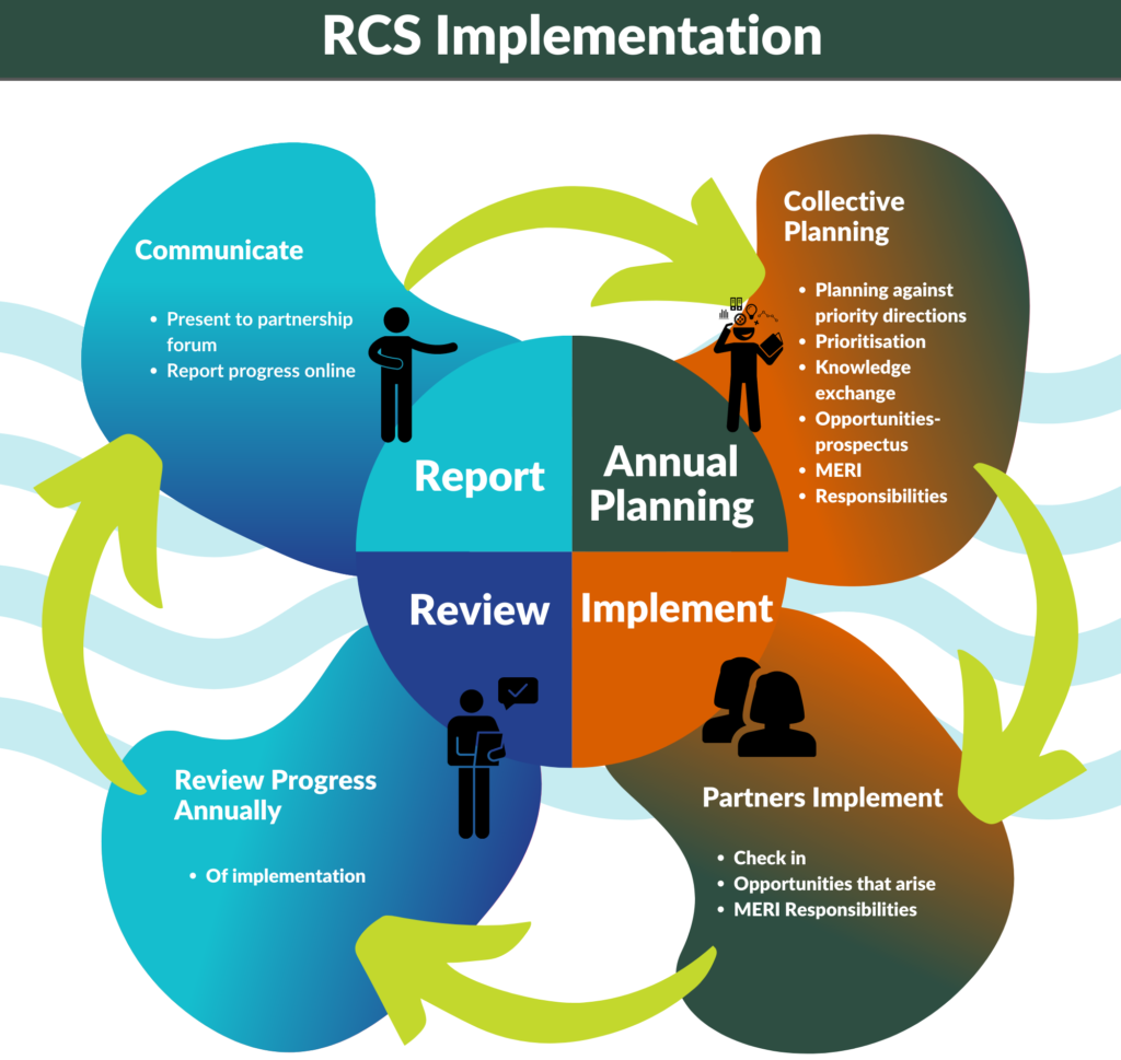
The image below illustrates the cyclic nature of the annual planning and review that will be used for RCS delivery. It captures how delivery partners will undertake annual collaborative planning, using the performance of the previous year to inform the forthcoming year. There will be the opportunity to:
- support funding opportunities that emerge for unfunded priority activities
- contribute as identified to the monitoring, evaluation and reporting processes and then use this information to inform the ongoing implementation of the strategy.
Numerous agencies, organisations, groups and individuals have direct and indirect interest and responsibilities in the management of natural resources across the Corangamite Regional Catchment Strategy area and will participate in the co-delivery of the Strategy.
Partners that currently have a role in NRM in the region and in delivering the RCS include State government agencies and authorities and local government:
Department of Environment, Land, Water and Planning
DELWP has a responsibility for setting policy for water, environment (including biodiversity and climate change) and land. At a regional level they play a crucial role in the implementation of biodiversity and land policy.
Water Authorities
Water Authorities deliver a range of services to customers and communities across their service areas, including the supply of drinking and recycled water, and the removal and treatment of sewage and trade waste – known as ‘urban’ water services. Their designated drinking water supply catchments are managed to ensure quality source water for drinking supply purposes. There are three water authorities in the region:
Agriculture Victoria
Agriculture Victoria works in partnership with farmers, industries, communities and other government agencies to grow and secure agriculture in Victoria. The organisation has broad regulatory responsibility within the agriculture portfolio and regulates biosecurity to protect food crops and livestock by keeping pests, invasive species and other organisms which may harm the environment, production systems and the safety of the human population.
Environment Protection Authority
The Environment Protection Authority (EPA) Victoria is Victoria’s environmental regulator. EPA is an independent statutory authority, established in 1971 under the Environment Protection Act 1970. EPA’s role is to prevent and reduce the harmful effects of pollution and waste on Victorians and their environment.
Parks Victoria
Parks Victoria is a statutory authority of the Victorian Government acting in accordance with the Parks Victoria Act 2018. Parks Victoria is responsible for managing a diverse estate of more than 4 million hectares including 3,000 land and marine parks and reserves making up 18 per cent of Victoria’s landmass, 75 per cent of Victoria’s wetlands and 70 per cent of Victoria’s coastline. Victoria’s parks are home to more than 4,300 native plants and around 1,000 native animal species.
Local Government
Local government contributes to the delivery of the outcomes of the Regional Catchment Strategy in a variety of ways. This includes the delivery of on-ground works in various areas of council owned/managed public open space, sports ovals and conservation reserves. and the maintenance and enhancement of trail networks and waterways including lakes and linear reserves.
Local government also has the ability to influence how land is used through the implementation of strategic objectives of the relevant planning scheme as well as individual land use planning decisions.
There are many other contributors to the management of natural resources across the region. These organisations or individuals may directly or indirectly contribute to the RCS.
Significant partnerships in the region include Traditional Owner groups, not for profit and community organisations, industry, land holders and urban communities.
Traditional Owners
Within the Corangamite region there are two Traditional Owner Groups who care and connect with Country in the region. The two registered Aboriginal organisations are:
Community
Corangamite region has a diverse community from highly urbanised, to visitor, to community. Furthermore we have a collection of active community involved in various natural resource management activities as well as landcare groups. These individuals along with individual land managers play a role in stewarding the region’s natural resources. While the implementation of the majority of priority directions within the RCS will be delivered with the support of community groups and individual landholders, the RCS is also a tool that can be used by these members of the community to inform their own funding bids by demonstrating a linkage to the RCS. The NRM Portal is a tool linked to the RCS that enables land managers to access information that supports their decision making regarding the most suitable use for that land.
Private land managers across the region contribute a significant amount to maintaining the health of the catchment. The management of land requires a large investment in both monetary terms and time. In the 2019 Social Benchmarking report, Professor Alan Curtis identified that of the nearly 600 respondents, 75% placed value on passing on a healthier environment.
Landcare groups and networks within the Corangamite Region play a key role in contributing to the delivery of the Regional Catchment Strategy having a major presence across the region. Landcare coverage within the region is identified in the Regional Maps section of this strategy, further information about Landcare in the region is available under the Landcare page of the Corangamite CMA website or from the Victorian Landcare Gateway.
In addition the region has a large citizen science base that contributes to the knowledge base for the region.
Industry Investment and Not for Profit Organisations
Southern Farming Systems is a farmer driven, non-profit organisation helping high rainfall farmers with independent, relevant, practical research and information that produces sustainable results.
WestVic Dairy is a regional team set up by Dairy Australia in the 1990s to deliver dairy extension activities and programs.
Trust for Nature partners with private landholders in Victoria to protect native plants and wildlife for future generations. Together with conservation covenants and reserves, we have protected more than 100,000 hectares across Victoria.
During the renewal of the RCS the CMA engaged with many other relevant industry groups who have expressed a desire to be more closely involved during implementation.
Australian Government
In addition to those organisations listed above, the Corangamite region works in partnership with the Australian Government to improve the natural resources of the region in numerous ways. The Australian Government’ Department of Agriculture, Water and Environment currently invests within the region through two major programs that support the delivery of its outcomes and priorities, namely Regional Land Partnerships and the Environmental Restoration Fund. The Corangamite Regional Land Partnerships – Natural Resource Management Plan 2022 to 2027 can be accessed here.