Overview
| Overall Area | 241,456 hectares |
| Population | 7,197 |
| Climate | 781 mm per annum at Camperdown 608 mm per annum at Beeac |
| Main Towns | Camperdown Cressy Beeac |
| Land Use | |
| Main Industries | Agriculture |
| Main Natural Features | Western District Ramsar site Lakes and Wetlands Stony Rises Woady Yaloak River Pirron Yallock Creek |
Landscape
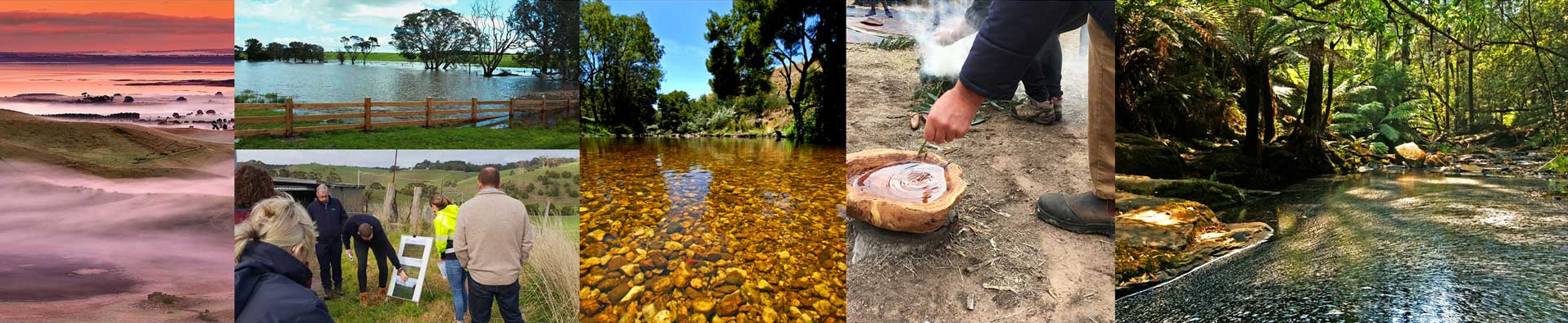
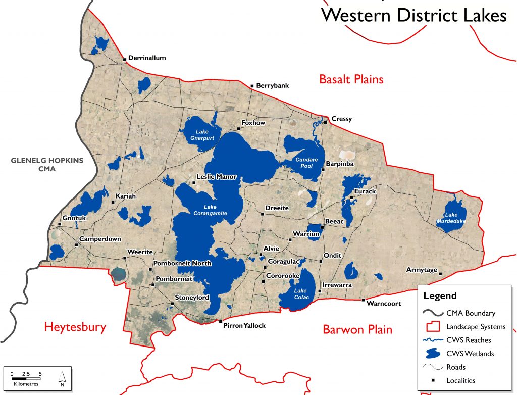
The Western District Lakes area is situated on the central western side of the Corangamite region. The major towns are Camperdown in the southwest and Cressy at the north. It borders the Basalt Plains to the north and east, and the Barwon Plains and Heytesbury to the south and southwest, respectively. The landscape is characterised by a large number of lakes and wetlands. The major municipalities are Corangamite and Colac Otway Shires, with a small portion of the Surf Coast municipality.
This landscape system is generally bounded by the Hamilton Highway to the north and the Princes Highway in the south. Its eastern boundary runs basically north from the Princes Highway near Birregurra to the Hamilton Highway between Cressy and Inverleigh (Wingeel). It contains the towns of Camperdown and Cressy within parts of the Colac-Otway and Corangamite Shires. The Traditional Owners are the Eastern Maar.
Within this landscape, lakes and wetlands have formed in volcanic craters, depressions due to lava collapse, and where drainage patterns have been interrupted by lava flows. Drainage is mostly internal to lakes or to groundwater. Seasonal variation in hydrology, the type of basalt substrate, and the great variety of catchment-to-surface area ratios and through-flows, combine to produce lakes and wetlands with an unusually wide range of salinities.
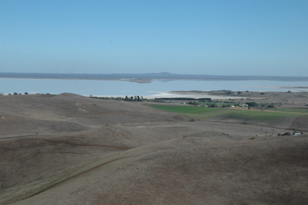
The area’s numerous lakes include nine listed under the Ramsar convention, the largest being Lake Corangamite. Lake Corangamite is the largest permanent saline lake in Australia, the largest natural lake in Victoria, a Ramsar listed wetland and a haven for migratory and non-migratory birds. The area also contains many other important Western District Ramsar site wetlands. The lakes are large, relatively shallow and dominated by open water. All of the lakes are saline except Lake Terangpom.
Undulating landscape of volcanic flows characterise the Stony Rises area, which represents the most recent volcanic activity in Australia. It is dotted with small wetlands, many of which form part of the seasonal herbaceous wetlands (freshwater) of the temperate lowland plains, which are listed as threatened under the Commonwealth Environment Protection and Biodiversity Conservation Act, 1999.
The landscape system has a number of creeks and streams that terminate at Lake Corangamite. The Woady Yaloak River and Pirron Yallock Creek flow into Lake Corangamite. Lake Colac, is also a dominant lake in this landscape, is fed from streams to the south including the Barongarook and Deans creeks.
Livelihood
Relative soil productivity on private agricultural land across the Western District Lakes is highly varied. Most of the region is private agricultural land (the rest being bodies of water), and ranges from moderate to high relative productivity in the south west, to low to moderate around the central north and eastern boundaries.
Taken from DELWP’s Victorian Land Cover Time Series (1985-2019), the most prevalent land cover classes in the Western District Lakes (excluding water) are non-native pastures, seasonal wetlands and, more recently, dryland cropping. Exotic woody vegetation, native grass herb, native trees and native scattered trees also each constitute a moderate proportion of land cover in the landscape system (each between 2-4% of the entire Western District Lakes).
Since 1985, non-native pasture has decreased in cover, dropping from 63% of the area to 53%. Dryland cropping, which occupied around 3% of the total landscape system in the 1985-90 epoch, has increased considerably, now comprising 13% of the total area.
Lifestyle
The Western District Lakes has a population of just under 7,200, and forms around 1.8% of the Corangamite region. This landscape system is the second least populated area of the region.
The smaller townships in this landscape provide it with a distinctively rural lifestyle, with Camperdown being the major population centre. Smaller townships such as Beeac, Cressy and Derrinallum support the local farming communities. The Western District Ramsar site is of significance to the community within this system with the myriad of wetlands defining the landscape. The stony rises are also a feature of this landscape and play a major role in defining the land use and lifestyle of the area.
Landcare groups in this Landscape are the Weerite, Leslie Manor, Cundare Duverney, Weering Eurack, Stony Rises, Leigh District, Irrewarra and Birregurra Landcare Groups.
Assessment of current condition and trends
Water
The Western District Lakes wetlands (Ramsar site no. 268), an iconic feature of the Corangamite region, was listed in 1982. It consists of nine large lakes on the Victorian Volcanic Plains between Winchelsea and Camperdown. Eight of these lakes are located within the Corangamite region, with Lake Bookar located in the adjacent Glenelg Hopkins CMA region. Eight of the nine lakes are saline (with Lake Terangpom being freshwater). Lake Corangamite is the largest wetland in the site.
The Western District Lakes area falls predominantly within the Lake Corangamite Basin, with all major waterways occurring within this basin. The eastern edge of the area, including Lake Murdeduke, falls within the Barwon River Basin. Although most of the reaches of the waterways that terminate in the major lakes exist outside this landscape system, the Western District Lakes includes reaches of the Pirron Yallock, Spring Gully, Dean and Barongarook Creeks in the south, and the Woady Yalaok River, Salt Creek, Mundy Gully and Gnarkeet chain of ponds in the north.
To the south of the landscape system, large areas of volcanic rock, formed from the most recent volcanic activity, are largely dominated by woodland interspersed with spring-fed freshwater wetlands, and have helped shaped the characteristic Stony Rises landscape. Many of these small wetlands are seasonal herbaceous wetlands (freshwater) of the temperate lowland plains, and are listed as under the Commonwealth Environment Protection and Biodiversity Conservation Act, 1999. Within the Stony Rises landscape zone, Lake Colongulac, Lake Beeac and Horseshoe Lake are included under the Western District Lakes Ramsar site.
Of the four reaches assessed as part of the Victorian Index of Stream Condition (ISC) during 2010, overall condition of the Western District Lakes area waterways ranges between very poor and poor, with one reach (of Woady Yaloak River) lacking sufficient information to determine overall condition. The reach of Salt Creek assessed was found to be in the worst overall condition, with lower reach of Mundy Gully and Pirron Yallock Creek assessed to be in poor condition.
There are two groundwater management units within the Lake Corangamite basin –Colongulac and Warrion, both upper basalt aquifers. While the rest of the basin is also largely basalt, salinity levels are higher and yield is lower outside of management areas. Groundwater is used for stock and domestic supply, as well as dairy, irrigation and industrial purposes. Within the Warrion Water Supply Protection Area (WSPA), the dairy industry is the dominant user. Groundwater resources, licensing and extraction in the Corangamite region are managed by Southern Rural Water, in line with the requirements of the Water Act 1989 and associated government policies.
Groundwater levels measured in ten bores across the Warrion WSPA show a return to normal seasonal variation over the past few years, with many bores showing a seasonal variance of about 1 metre. While many lakes in the area have been identified as having a connection to groundwater, no reported concerns have been identified regarding the extraction of groundwater on groundwater dependent ecosystems.
Biodiversity
The lakes system supports a large number and diversity of bird species with records as high as 100,000+ birds at one time with certain wetlands recognised internationally for their values as bird habitat through the Ramsar convention. A total of 70 species of wetland birds have been recorded within the site. The list includes 20 species that are listed under international migratory agreements CAMBA, JAMBA, ROKAMBA and the Bonn Convention, and 26 species listed as migratory or marine under the EPBC Act.
The lakes also support number of federally listed threatened species, including the migratory shorebirds listed above, the Corangamite water skink, Spiny Peppercress (lepidium ascersonii), Salt-lake Tussock-grass (poa sallacustrisis) as well as many state-listed threatened species.
DELWP’S Habitat Distribution Models identify rare or threatened species with more than 20% of their Victorian modelled range. These include: Corangamite Water Skink (Eulamprus tympanum marnieae), Spiny Peppercress (Lepidium aschersonii), Wind-flattened Tussock-grass (Poa physoclina), Salt-lake Tussock-grass (Poa sallacustris), Clumping Leek Orchid (Prasophyllum sp. aff. Occidentale), Leprechaun Greenhood Orchid (Pterostylis conferta), Dense Greenhood Orchid (Pterostylis sp. aff. bicolor (Woorndoo).
The landscape has over 15,100ha of threatened Ecological Vegetation Classes (EVC) with fragmented areas of endangered Plains Grassland, Plains Grassy Woodland, Plains Grassy Wetland and Plains Sedgy Wetland EVCs. Smaller amounts of Aquatic Herbland/Plains Sedgy Wetland Mosaic, Swamp Scrub and Plains Sedgy Wetland vegetation communities can also be found. Scoria Cone Woodland is also known to occur along the volcanic rises. The Victorian Biodiversity Atlas has records of 28 Federally protected species, 59 State protected species and 105 rare or threatened species on the Victorian Advisory List occurring within the landscape.
Vegetation along waterways in the Lake Corangamite Basin was the poorest across the entire Corangamite region. Among the poorest reaches were all four sites assessed in the Western District Lakes, which all scored badly in all parameters.
Land
Relative soil productivity on private agricultural land across the Western District Lakes is highly varied. Most the region is private agricultural land (the rest being bodies of water), and ranges from moderate to high relative productivity in the south west, to low to moderate around the central north and eastern boundaries.
Taken from DELWP’s Victorian Land Cover Time Series (1985-2019), the most prevalent land cover classes in the Western District Lakes (excluding water) are non-native pastures, seasonal wetlands and, more recently, dryland cropping. Exotic woody vegetation, native grass herb, native trees and native scattered trees each constitute a moderate proportion of land cover in the landscape system (each between 2-4% of the entire Western District Lakes).
Since 1985, non-native pasture has decreased in cover, dropping from 63% of the area to 53%. Dryland cropping, which occupied around 3% of the total landscape system in the 1985-90 epoch has increased considerably, now comprising 13% of the total area. Exotic woody vegetation increased moderately, from 1.5% to 2.25% of the total landscape system. Urban areas more than doubled, but still constitute <0.5% of the landscape system. Although seasonal wetlands increased in coverage, the far less prevalent perennial wetlands decreased by almost half.
Community
The Western District Lakes has a population of just under 7,200 and forms around 1.8% of the Corangamite region. This landscape system is the second least populated area of the region. Although among the largest landscape systems by area, the Western District Lakes has the lowest population density of the Corangamite region. The single most densely populated area of the Basalt Plains is the township of Camperdown.
Landcare groups in this Landscape are the Weerite, Leslie Manor, Cundare Duverney, Weering Eurack, Stony Rises, Leigh District, Irrewarra and Birregurra Landcare Groups.
Landcare groups in this landscape are supported by the Heytesbury District Landcare Network, Lismore Land Protection Group, Leigh Catchment Group, Geelong Landcare Network and Upper Barwon Landcare Network.
Other environmental groups:
- Alvie Tree Planters
- Camperdown Timboon Rail Trail Committee of Management
- Friends of Mt Leura
- Mount Elephant Community Management
- Mt Leura and Mt Sugarloaf Reserves Committee
- Red Rock Reserve
Major threats and drivers of change
Water
The majority of this landscape system contains wetlands associated with the Western District Lakes Ramsar site which are fed by waterways including the Pirron Yallock, Spring Gully, Dean, Salt and Barongarook Creeks, along with the Woady Yalaok River and Mundy Gully and Gnarkeet chain of ponds. Many of the wetlands are also dependent on ground water flows. Some are naturally saline while others are fresh.
The major threats to waterways and wetlands in this landscape system generally relate to what is happening in the broader catchment. Any impacts on flow regimes will have an impact on not only the waterways but also the wetlands into which they drain. A major threat to naturally saline wetlands is invasion by introduced salt-tolerant species such as Tall Wheat Grass, whilst freshwater wetlands are susceptible to saline intrusions as a result of dryland salinity.
Climate change also represents a major issue for the wetlands of this landscape system. There is likely be a decrease in the number and area of permanent and seasonal wetlands and an increase in the number and area of intermittent wetlands, especially those that are completely rainfall dependent. Wetlands that are dependent on groundwater will also be largely impacted by climate change though reduced inflows.
Biodiversity
Tall wheatgrass (Thinopyrum ponticum) is a drought-tolerant, summer-active, tussock-forming perennial that grows two metres high and is used to restore land affected by salinity. It is also a serious weed that invades native ecosystems, reducing biodiversity and creating monocultures. Tall wheatgrass has been identified as a threat to a number of wetlands in the Western District Lakes landscape system. Other weeds of concern include Gorse, Boxthorn and Blackberry while foxes, rabbits and wild pigs can be problematic.
DELWP’s Biodiversity Response Planning includes Strategic Management Prospect (SMP) threat control actions which align with Protecting Victoria’s Environment- Biodiversity 2037 targets. The following actions fall into the top 3% most cost-effective actions with the greatest net benefit to all biodiversity:
- rabbit control
- weed control
- permanent protection
- feral pig control
- domestic grazing control.
Land
The major threats to soil and land use in this landscape are secondary salinity, soil structure decline, water logging, soil nutrient decline and soil acidification (see Static Maps section for mapped soil threats).
Since the widespread land use change associated with European settlement, secondary salinity has developed in dryland agricultural areas within this landscape system. The salinity processes are associated with changes to the groundwater and/or soil hydrology.
Soil structure decline and associated compaction of soils generally resulting from livestock and/or machinery traffic under wet soil conditions can lead to water logging.
Maintaining a cost-effective balance of available plant nutrients is an important component of land management. Sustainable land use requires the replacement of extracted nutrients. Nutrients can also be lost from the soil through leaching into the deeper soil profile, in run-off or through soil movement leading to issues in plant growth and associated soil health problems.
Soil acidification is a process that is more common in sandier soils, where nitrogen/nitrate leaching occurs more readily and is most prevalent in areas of higher agricultural production. Low soil pH reduces the availability of essential nutrients such as phosphorous and molybdenum, and increases the availability of toxic elements such as aluminium and manganese. Low pH also makes the environment unsuitable for many soil microbes.
Community
Although among the largest landscape systems by area, the Western District Lakes has the lowest population density of the Corangamite region and does not have a good coverage of community groups. The large wetlands within the area create barriers between townships and and community connection.
The absorption and/or corporatisation of properties into conglomerates is also a threat to the communities within this landscape. There are not many large towns within this system, although Colac is in close proximity, which can impact on the farming community. Many of the towns such as Camperdown and Cressy rely heavily on the agriculture sector and the health of their communities can often be mirrored by the health of the sector.
The aging demographic of farmers within this landscape is also of concern, especially in relation to active community participation.
Western District Lakes 6 Year Outcomes
Water
By 2027, compared to 2022 baselines:
The ecological characteristic of priority wetlands are improved. WDLWO1
Maintain or improve the ecological character of the Western District Lakes Ramsar site. WDLWO2
Maintain groundwater interaction with the priority wetlands. WDLWO3
Increase the community understanding and awareness of water values and management of the Western District Lakes system. WDLWO4
Understand and enhance the Eastern Maar values of the Western District Wetlands and tributary rivers and ensure a strong Eastern Maar voice in their management. WDLWO5
Improve waterway amenity of the Western District Lakes to enhance the user experience and connection to the natural landscape. WDLWO6
Biodiversity
By 2027, compared to 2022 baselines:
Achieve a net gain in the overall extent, connectivity and condition of Western District Lakes habitats across land and waterway environments through effective climate change adaptation strategies. WDLBO1
Achieve a net gain where possible in suitable Western District Lakes habitat expected over six years from sustained improved public and private land management and community involvement for threatened and culturally significant local species. WDLBO2
Achieve a net gain where possible in all species with positive % change in suitable Western District Lakes habitat and improved species balance expected over six years from sustained improved public and private land management and community involvement. WDLBO3
Increase effectiveness of interagency collaboration in their ability to respond to climate change and development pressures on biodiversity. WDLBO4
Increase understanding and awareness of biodiversity values of the Western District Lakes Landscape System. WDLBO5
Land
By 2027, compared to 2022 baselines, land is suitably used within its capability and sustainably managed to maintain and improve its’ natural capital. WDLLO1
Communities
By 2027, compared to 2022 baselines:
Western District Lakes communities (and visitors) are encouraged, educated and enabled to further connect with and responsibly care for the natural environment. WDLCO1
Western District Lakes communities (and visitors) have an increased awareness and understanding of the connection between human activities and impacts on the environment. WDLCO2
The increased capacity of the Eastern Maar Traditional Owner Group enables their increased involvement in decision making that effects their Country. WDLCO3
Western District Lakes 6 Year Priority Directions
Six year regionally applicable priority directions have been developed for each of the Themes and are applicable to this landscape System, these can be accessed via the following links:
Six year priority directions for the Western District Lakes are provided in the following table. Where these priority directions apply to a theme this is indicated by the relevant shading. To access definitions of terms and acronyms click on the following link.
Code |
Priority Direction |
Relevant Theme | ||||||
|---|---|---|---|---|---|---|---|---|
| Water | Biodiversity | Land | Community | Lead | Collaborators | |||
| WDL1 | Western District Lakes landscape partners and the community collaborate to deliver a coordinated approach to natural resource management to build resilience and successfully respond to changing circumstances with clear roles and responsibilities communicated. | CCMA | DELWP, Water Authorities, EPA, COS, CS, SCS PV. | |||||
| WDL2 | Develop enduring partnerships with the Eastern Maar people to: 1) acknowledge and enhance Eastern Maar values of natural assets; 2) ensure the Eastern Maar people have a strong say in management of natural assets; 3) identify and implement appropriate mechanisms for sharing Eastern Maar stories and history; and, 4) identify and implement opportunities for the Eastern Maar to own and manage water on their country |
CCMA | EMAC, DELWP, Water Authorities, COS, CS, SCS | |||||
| WDL3 | Best land management practices are implemented across farmers, agencies, developers, and the catchment community | CCMA | AgVic, Landcare | |||||
| WDL4 | Implement the Western District Lakes Ramsar Management Plan. | CCMA, PV | DELWP, COS, CS, SCS, EPA, SRW, GHCMA | |||||
| WDL5 | Landuse planning, works on waterways, floodplain management and water management decisions to take into account the potential impact of proposals on the natural function of floodplains, waterways and the riparian zone. | CCMA | COS, CS, SCS | |||||
| WDL6 | Ensure the assessment of applications for new or transfers of groundwater entitlements in the Warrion and Colongulac Groundwater Management Areas takes into account the impact of extraction on Groundwater Dependent Eco-systems (GDEs) | SRW | CCMA | |||||
| WDL7 | Help farmers prepare for a more variable and uncertain future by: 1) Supporting farmers with the information and tools to build resilience 2) Preparing farmers for a range of future scenarios 3) Helping farmers manage climate risk so they remain productive and profitable under a changed climate 4) Delivering the agriculture skills of the future |
AgVic | CCMA, DELWP, Landcare | |||||
| WDL8 | Ensure development planning considers, minimises and where possible avoids adversely impacting floodplains, biodiversity, land and water assets including encouraging water sensitive urban design and use of integrated water management principles and requiring developers to: 1) protect and enhance native vegetation and habitat 2) protect and enhance floodplain function 3) protect cultural heritage |
COS, CS, SCS | CCMA | |||||
| WDL9 | Ensure community education and engagement activities are grounded in the most recent and relevant social research available and target local demographics. | CCMA | DELWP, COS, CS, SCS, Water Authorities | |||||
| WDL10 | Apply responsible on-farm water management so that agriculture does not adversely impact wetlands | CCMA | AgVic, DELWP, Landcare | |||||
| WDL11 | Western District Lakes landowners have a greater appreciation for environmental values and benefits to agricultural production | CCMA | Landcare | |||||
| WDL12 | Encourage and enable community participation (volunteering) 1) in on-ground environmental works to restore and protect environmental assets 2) citizen science programs |
CCMA | Landcare | |||||
| WDL13 | Engage with the community on the need to mitigate and adapt to climate change and its impacts. | CCMA | DELWP, Landcare, COS, CS, SCS | |||||
| WDL14 | Integrate the understanding of new and emerging impacts such as wind farms and climate change. | DELWP | ||||||
| WDL15 | Action Plans are developed that leads to a 25% increase of non-government investment into the region to address high priority biodiversity actions | CCMA | DELWP, COS, CS, SCS, Landcare | |||||
| WDL16 | Develop best practice management actions to achieve an overall net gain of ‘Suitable Habitat’ for priority species by 2027 | CCMA | DELWP | |||||
| WDL17 | Engage with TO’s to develop a method based on traditional knowledge that enables improved and sustained management of problem herbivores in priority locations | DELWP | EMAC | |||||
| WDL18 | Implement additional areas of sustained predator, herbivore and weed control in priority locations, reflecting Biodiversity Response Planning outputs, Strategic Management Prospects and other regional plans | DELWP | CCMA, Landcare, PV | |||||