Overview
| Overall Area | 112,802 hectares |
| Population | 6,079 |
| Climate | 956 mm per annum at Timboon 836 mm per annum at Cobden |
| Main Towns | Cobden Timboon Peterborough Port Campbell Princetown |
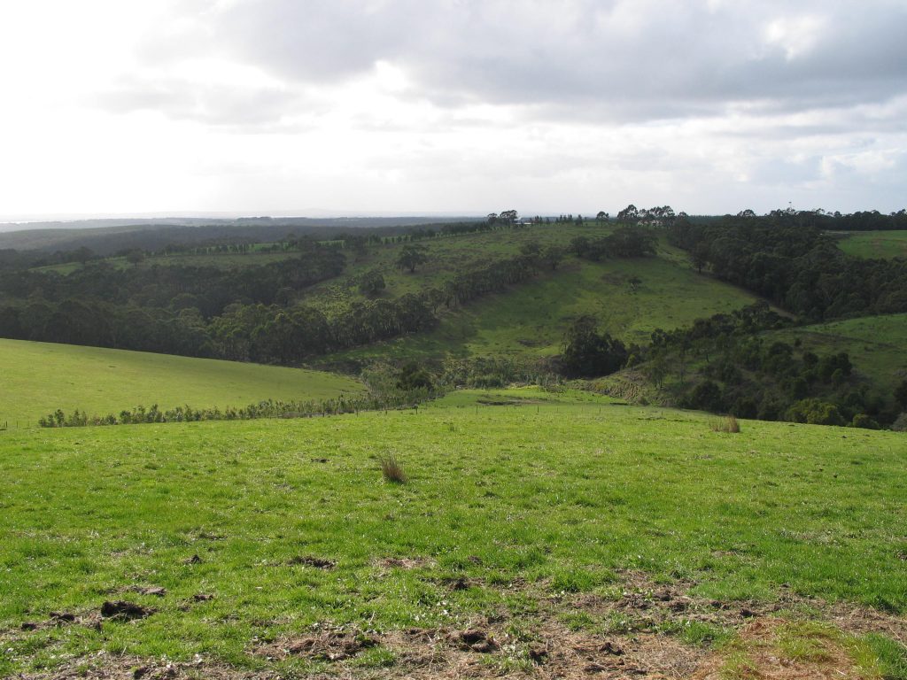
| Land Use | Cattle grazing |
| Main Industries | Dairy Beef Tourism |
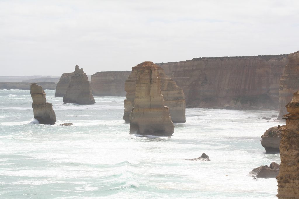
| Main Natural Features | The Twelve Apostles Loch Ard Gorge Bay of Islands Coastal Park Shipwreck Coast Port Campbell National Park Curdies River Curdies Estuary |
Landscape
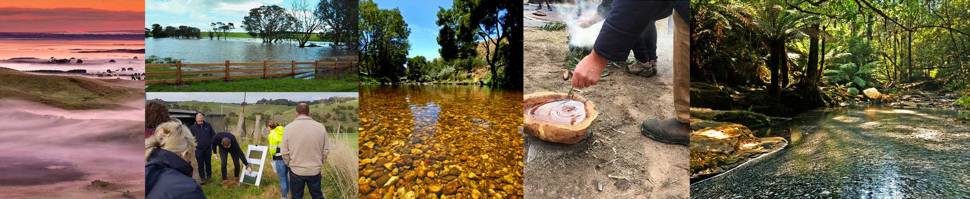
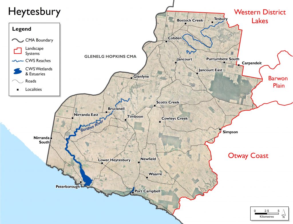
The Heytesbury landscape system is located in the south west of the region and is bounded by Bass Strait to the south, Glenelg-Hopkins CMA to the west, the Otway Coast and Barwon Plains to the east with its northern boundary adjoining the Western District Lakes system. It contains the towns of Cobden, Timboon, Peterborough, Port Campbell and Princetown. The local governments covering this system are Colac-Otway and Corangamite Shires, with a small portion of Moyne Shire included around Peterborough (west of the Curdies River). The Eastern Maar are the traditional owners of this area.
This landscape system is internationally renowned for its coastline, which has been sculpted over thousands of years to become one of the most impressive natural sites in Australia. Rock stacks, sheer limestone cliffs, as well as arches, islands and blowholes have been carved out of the soft cliffs by the wind and sea. The Twelve Apostles, Loch Ard Gorge, Bay of Islands Coastal Park, Shipwreck Coast and Port Campbell National Park are all in this system. Parts of the Great Otway National Park also extend throughout this landscape system and are of significant environmental, cultural, social and economic value to the region.
The major waterway for this landscape system is the Curdies River and associated tributaries. Other significant waterways in the area include Port Campbell Creek and Sherbrook River. The waterways in the Heytesbury landscape system are largely valued for their environmental condition, social amenity and economic value to the community. The Curdies estuary is among the largest within the region that is a salt wedge estuary protected under the EPBC Act.
Livelihood
The Heytesbury region forms part of one of the largest milk producing regions in Australia. As many of the smaller towns in this landscape including Cobden and Timboon rely heavily on the dairy industry the viability of these communities is dependent on the viability of dairying.
The coastal communities of Port Campbell and Peterborough are also imacted on by coastal processes and utilisation. The area has become very popular to tourists and this again has an impact on the community.
Lifestyle
This landscape system is internationally renowned for its coastline, which has been sculpted over thousands of years to become one of the most impressive natural sites in Australia. Rock stacks, sheer limestone cliffs, arches, islands and blowholes have been carved out of the soft cliffs by the wind and sea. The Twelve Apostles, Loch Ard Gorge, Bay of Islands Coastal Park, Shipwreck Coast and Port Campbell National Park are all in this system. Parts of the Great Otway National Park also extend throughout this landscape system and are of significant environmental, cultural, social and economic value to the region.
Parts of the Heytesbury were a soldier settlement established after World War 2. The scheme, established in 1960, involved the clearing of the Heytesbury Forest south of Colac and adjacent to the Otway Ranges to allow for the establishment of a dairy industry in the area. The scheme developed a strong community spirit among settlers that is still part of the character of the people who live in the Heytesbury area today.
The Heytesbury landscape system has the lowest population of the Corangamite region with a population of just over 6,000 with low density. The most densely populated area is the township of Cobden. Low population density can impact on the community, especially where farmers are becoming older and less active.
Landcare groups in this landscape include Bostocks Creek, Elingamite Cobrico, Curdies Valley and Newfield Valley Landcare Groups. They are supported by the Heytesbury District Landcare Network.
Key values identified in this landscape include:
- known rare and threatened species
- significant Ecological Vegetation Classes
- rural water source
- aquatic invertebrate communities
- recreation including camping, picnics and barbecues, sightseeing, game hunting, boating,
- fishing, swimming and walking tracks.
Assessment of current condition and trends
Water
Landcare groups have been running programs to improve the health of waterways, addressing issues including soil acidification, improving biodiversity on public and private land, controlling weeds, etc.
The waterways of the Heytesbury area fall within the Otway Basin. The major waterway of this area is the Curdies River and its associated tributaries. The Curdies River connects with the Peterborough Coastal Reserve, the Cooriemungle, Black Glen and Scotts Creeks to the east of the area. The Port Campbell Creek also flows in the south of the Heytesbury area. Many of the rivers and streams in this landscape system are small or intermittent.
In the Victorian Index of Stream Condition assessments during 2010, the waterways of the Heytesbury area were found to be in mixed condition. Of the Otway Basin (the highest scoring condition catchment basin in the Corangamite region), the Heytesbury area contains the waterways with lowest scoring condition, and no waterways in excellent condition. Port Campbell Creek’s condition was assessed as good – the highest of the Heytesbury area. The highest and lowest reaches of the Curdies river were found to be in very poor condition, with the rest of the Curdies River and tributaries assessed to be in moderate condition. All waterways assessed showed elevated levels of phosphorus.
Drought has a significant impact on flow stress in the Otway Basin, with the reach of the Curdies River in the central part of Heytesbury landscape system among the most affected by drought. While much of the Otway Basin outside of the Heytesbury area had near natural flow regimes, the central and southern reaches of the Curdies River experience highly modified flows as an impact of farm dams and diversions. Additionally, the entire Curdies River exhibits summer stress and long periods of low flows.
Corangamite Waterwatch, a citizen science volunteer program, regularly monitors water quality parameters at many sites across the catchment, including the Curdies and associated tributaries. Monitoring undertaken in the upper catchment of the Curdies River (2014 to 2017) indicates the waterway to be in marginal to moderate condition, whilst displaying low salinity and turbidity, and relatively healthy pH levels. Low oxygen levels on occasions potentially indicate high instream oxygen demand. Monitoring in Scotts Creek following rainfall events (2011 to 2014) indicate high sediment and phosphorus loads are carried in the runoff into this tributary during these times, likely linked to unrestricted stock access and reduced riparian vegetation along the waterway.
Further down the catchment, monitoring undertaken during the fish eDNA project (2019) suggests improvements occur with low salinity and turbidity, and improved oxygen levels indicating the waterway to be in moderate condition. All riverine sites indicate there to be high phosphorus inputs to the Curdies River, also likely associated with farming practices in the area. High phosphorus inputs can lead to excessive macrophyte and algal growth, whilst high sediment inputs can smother submerged aquatic vegetation and habitat for fish and aquatic macroinvertebrates.
In the Curdies River estuary (2014 to 2020) the water quality was moderate to good, displaying healthy oxygen and pH levels and mostly low turbidity. Being an intermittently open estuary, salinity levels varied throughout the estuary being fresh to brackish in the upper estuary and brackish to saltwater in the lower estuary. During most openings of the estuary mouth – usually in winter – the estuary is flushed of saltwater by increased freshwater river flows, tidal influences reintroduce salt water to the estuary and after a short period, as river flows decline, the estuary mouth closes.
Biodiversity
The majority of remaining native vegetation in the Heytesbury landscape system are classed as rare or vulnerable, with some areas classed as endangered. This is generally a reflection of the clearing that has taken place to enable agricultural production in this highly productive area. There are some areas of reserved public land in the area but these have been impacted by timber harvesting for a variety of purposes.
The Curdies estuary at Peterborough and adjoining shallow waters provide significant habitat that support the lifecycle of many fish species, including migration, spawning and rearing of juveniles. Yellow-eye mullet (Aldrichetta forsteri) juveniles will utilise seagrass beds in the estuary and Estuary Perch (Macquaria colonorum) and Black Bream (Acanthopagrus butcheri) use the estuary for all life stages. The shallow water adjoining the estuary provides important foraging habitat and a refuge for juvenile fish of many species. The Yarra Pygmy Perch (Nanoperca obscura) has also been recorded in the estuary and is listed as vulnerable at state and national level.
The Victorian Biodiversity Atlas identifies almost 40 bird species listed as rare or threatened on the Victorian Advisory List for the area, including 8 that are listed under the Commonwealth Environment Protection and Biodiversity Conservation (EPBC) Act 1999. These include: Curlew Sandpiper (Calidris ferruginea), Eastern Curlew (Numenius madagascariensis), Great Knot (Calidris tenuirostris), Australasian Bittern (Botaurus poiciloptilus), and Orange-bellied Parrot (Neophema chrysogaster).
Important habitats for birds and other species vary with water levels and include:
• extensive areas of open water of varying depth
• mudflats
• vegetated areas
• sandy shores.
Several significant vegetation communities are represented at the Curdies River estuary, including at least 14 different Ecological Vegetation Classes (EVCs). A stand of Estuarine Wetland, which is noted as one of the largest in southeast Australia and is listed as depleted across the Warrnambool Plain bioregion is found at the estuary. Other vegetation classes of note include Swamp Scrub, which has a bioregional conservation status of ‘endangered’ – it is within this vegetation community that the nationally vulnerable Swamp Greenhood orchid (Pterostylis tenuissma) has been recorded. Similarly, a large population of the nationally vulnerable species Curly Sedge (Carex tasmanica) has been recorded in the Brackish Grassland EVC.
However, despite some significant EVCs and individual species, vegetation is predominantly degraded in estuarine areas, including along the Curdies River (around the Peterborough Coastal Reserve). The upper reach of the Curdies River also exhibits poor vegetation quality.
Land
Generally, soil health in the Heytesbury area is in the healthiest condition of the Corangamite region. Soil productivity on private agricultural land in the Heytesbury area is consistently the highest in the Corangamite region.
The Heytesbury region forms part of one of the largest milk producing regions in Australia.
DELWP’s Victorian Land Cover Time Series provide a snapshot of the changes in land cover types in seven five-year increments between 1985-2019.
The most prevalent land cover class in Heytesbury is non-native pasture, followed by native trees. Non-native pasture cover has fallen over the 30 year period, from 85% of the total area, to 81%. Native trees, which constitute around 10% of total land cover, have remained constant over the time period. Irrigated horticulture, hardwood plantations and exotic woody vegetation (previously all <1%) now constitute a moderate proportion of land cover for the region, occupying 1.9%, 1.3% and 2.1% of the total area respectively. Urban areas have more than doubled to cover 0.8% of the Heytesbury landscape system. Both seasonal and perennial wetland land cover decreased slightly over the time series.
Coast and Marine
The condition of coastal waters is generally good, with low levels of nutrients, turbidity and bio-contaminants, and generally good light conditions. Wave energy along the coast is high with waves generated from the large incoming swells of the Southern Ocean.
Heytesbury has some spectacular and well recognised coastal landscapes that are integral to the identity of the state and its people, including the iconic offshore rock formations of the Twelve Apostles. The Twelve Apostles Marine National Park and The Arches Marine Sanctuary are along this coastline.
The Heytesbury marine area has high species richness and diversity. Marine species and communities are susceptible to a range of threats ranging from local to global scales. For example, long-lived fish species with limited reproductive potential are most susceptible to overfishing.
Large sections of the coastline within the Heytesbury landscape system are moderately erodible which can present some issues with maintaining not only the coastline itself but the impact of such events on other natural and built assets.
Key ecological vegetation classes that occur within this landscape system include Costal Dune Scrub/Grassland mosaic, Coastal Saltmarsh, Coastal Headland Scrub, Coastal Tussock Grassland and Coastal Alkaline Scrub.
Community
The Heytesbury landscape system has the lowest population of the Corangamite region with a population of just over 6,000 – around 1.5% of the total population. Its population density is also low, with the most densely populated area being the township of Cobden.
Active local communities and groups continue to conduct work on these other waterways. An example includes projects managed through the Heytesbury District Landcare Network aimed at soil acidification and reduced organic material and the promotion of increased biodiversity on public and private land. A large component of the activities completed as part of these initiatives involves fencing off, revegetating and controlling weeds (including Willows) on a number of waterways.
Landcare groups in this Landscape include Bostocks Creek, Elingamite Cobrico, Curdies Valley and Newfield Valley Landcare Groups. They are supported by the Heytesbury District Landcare Network.
Other environmental groups:
- Friends of Cobden Lake
- Friends of Port Campbell National Park
- Friends of Timboon Rail Trail
- Port Campbell Biolinks
- Timboon Junior Rangers
Major threats and drivers of change
Parts of the Curdies River and associated tributaries and estuary have been subjected to grazing pressures. Livestock access to waterways can erode banks, damage riparian vegetation and reduce water quality through sedimentation and effluent contamination. Willows have been identified as a threat in the upper reaches of the Curdies River and in the longer term dispersal may compromise the condition of downstream reaches of the river system. Other waterways such as Cooriemungle, Scotts, Fentons, Wallaby, Spring, Squirrel, Whisky and Mosquito creeks are also important.
Water
Parts of the Curdies River and associated tributaries and estuary have been subjected to grazing pressures. Livestock access to waterways can erode banks, damage riparian vegetation and reduce water quality through sedimentation and effluent contamination.
Willows are a threat in the upper reaches of the Curdies River and in the longer term their spread may compromise the condition of downstream reaches of the river system.
The Curdies River estuary intermittently opens or closes depending on the prevailing conditions, with estuary closure sometimes resulting in social and economic impacts through flooding of adjacent land. Artificially opening the estuary under certain conditions can result in adverse impacts to the surrounding environment and its associated species.
Projected sea level rise, temperature increase, reduction in rainfall and an increase in extreme natural events (i.e. flooding) are all expected to impact the ecology and dynamics of the waterways, wetlands and estuaries within this landscape system. The coastal impacts associated with climate change pose a significant threat to the Curdies River estuary. Sea level rise of 0.8-1.1m is forecast by 2100, as well as an increase in storm surge events. According to the Corangamite NRM Plan for Climate Change these influences, combined with a reduction in rainfall, create a high climate change risk for the Curdies estuary.
The Corangamite Waterway Strategy 2014-2022 outlines priority management activities to address water quality threats in the Heytesbury landscape. These include:
- Establish terrestrial pest animal control – fox control (as part of a large scale coordinated program)
- Establish native indigenous vegetation (Curdies River, Curdies Inlet)
- Install riparian/wetland fencing (Curdies River, Curdies Inlet)
- Establish stewardship/management agreement (Curdies River, Curdies Inlet)
- Assess options for long-term management land subject to inundation (Curdies Inlet)
- Undertake woody weed control (Curdies River)
- Continue to adopt a risk-based approach to estuary mouth opening (Curdies Inlet)
- Review and update current estuary management plan – Curdies Inlet
- Maintain EstuaryWatch groups collecting baseline data on estuary condition (Curdies Inlet)
- Maintain Waterwatch groups collecting baseline data on waterway condition
Biodiversity
Increased usage of the Curdies estuary may have negative impacts if not carefully planned for and managed. Potential impacts may include littering, trampling of vegetation and habitat disturbance, bank erosion due to inappropriate access, the introduction and spread of weeds and illegal shooting and camping. Urban encroachment and inappropriate development around the estuary also has the potential to impact on the natural values of the estuary and the installation of hard infrastructure may restrict the ability for a more natural flood regime to be achieved; this too must be carefully managed and planned for.
Over 50 species of introduced flora have been reported at the Curdies River estuary, including a number of common agricultural weeds that dominate the landscape in places where native vegetation is cleared (DELWP 2016). Livestock grazing, resulting in the reduction of indigenous vegetation cover, spread of weeds, particularly Tall Wheat Grass (Lophopyrum ponticum) and pugging have been identified as the main threats to remnant estuarine vegetation at the Curdies. The encroachment of domestic garden plants into surrounding native vegetation has also been identified as a threat.
Infestations of weeds can out-compete native species, resulting in changes to the structure, species composition and abundance of native vegetation communities.
Willows (Salix spp.) are a Weed of National Significance and are known to adversely impact waterways through reducing water quality and availability, increasing erosion and flooding potential, and reducing aquatic and riparian biodiversity. Willows were identified as a threat in the upper reaches of the Curdies River and in the longer term dispersal may compromise the condition of downstream reaches of the river system.
The red fox (Vulpes vulpes) was identified as a threat to significant bird species inhabiting or visiting the wetlands and estuary of the lower Curdies River.
Land
Landslides, secondary salinity, acid sulphate soils, sheet/rill erosion and soil structure decline present the major threats to soil and land use (see Static Maps section for mapped soil threats).
The steepness of the slope is often a causal factor for landslides in this landscape system; high rainfall is also a trigger. How the land is being used and the introduction of infrastructure can also contribute to landslides with inappropriate agricultural practices or environmental works potentially increasing landslide risk.
If the soils in this landscape system become waterlogged, the lack of oxygen in pore spaces over sustained periods severely affects plant growth. In wet and compacted soil horizons, where the air porosity is low, poor soil aeration is exacerbated by the production of toxic compounds produced by soil micro-organisms. This can lead to soil structure decline and its associated risks.
Coast and Marine
The Victorian Marine and Coastal Policy identifies that the health of the marine and coastal environment is under threat from multiple sources, including climate change and growth in towns, cities and industries that interact with their local marine and coastal ecosystems.
These threats can lead to negative impacts on water quality and quantity, pollution and debris, invasive species, marine pests and diseases, disturbance and loss of plants and animals, and loss of access to beaches from the effects of sea walls, infrastructure and erosion. Degradation occurs over time and space, and the impacts in marine and coastal areas are varied and complex.
Climate change is increasing the pressure on the marine and coastal environment by exacerbating existing threats and introducing new ones, including:
• rising sea levels, leading to more inundation and erosion
• increased frequency and severity of storms and other extreme weather events
• changes in ocean temperatures, currents and acidification
• changes to waterway flows, levels and regimes
• changes in the range, distribution and abundance of both introduced and native plants and animals, taking advantage of a changed climate.
There are a number of locations along the Heytesbury coastline that are already susceptible to erosion, this will be increased under climate change scenarios, especially with the prediction of increased frequency of storms and extreme weather events. Sea level rise under climate change will have a major effect on low ling coastal areas, especially where there are estuaries.
Growth in resident populations and visitor numbers puts pressure on the health of the marine and coastal environment. Population growth also increases pressure on recreational infrastructure such as walking tracks and visitor facilities. This, in turn, leads to more demand for alterations to beaches, foreshores, wetlands and natural processes through groynes, sea walls and dredging to support use and development.
Community
The Heytesbury landscape system has the lowest population of the Corangamite region with a population of just over 6,000 with its population density also being low, with the most densely populated area being the township of Cobden. This in itself can impact on the community, especially where farmers are becoming older and less active. The Heytesbury District Landcare Network is active in this area and provides support to the community in managing the natural assets of the area.
The area is highly dependent on the dairy industry with profitability being directly aligned with commodity prices. As many of the smaller towns in this landscape including Cobden and Timboon rely heavily on the dairy industry, the viability of these communities is dependent on the viability of dairying.
The coastal communities of Port Campbell and Peterborough are also impacted on by coastal processes and utilisation. The area has become very popular to tourists and this again has an impact on the community.
Emergency events such as riverine flooding, flash flooding, storm surge, landslides and debris resulting from bushfire, as well as other events such as pollution, boating incidents and drownings pose a risk to those who live, use and enjoy the area.
Peterborough has a history of being impacted by flooding from the Curdies River when the mouth is closed, with impacts including flooding of the caravan park and dwellings and inundation of roads.
Heytesbury 6 Year Outcomes
Water
By 2027, compared to 2022 baselines:
There is an improvement in riparian extent and condition and water quality in priority reaches as defined in the Corangamite Waterway Strategy. HeyWO1
Maintain or improve water quality of the Curdies River estuary compared to Index of Estuary Condition 2019. HeyWO2
Increase the community’s understanding and awareness of water values and management in the Heytesbury Landscape System. HeyWO3
Ensure Eastern Maar people have a strong voice in the management of waterways in the Heytesbury Landscape System and cultural values are incorporated. HeyWO4
There will have been an increase in the Curdies River estuary in stream habitat for native fish and angling species compared to 2021 baseline. HeyWO5
Biodiversity
By 2027, compared to 2022 baselines:
Achieve a net gain in the overall extent, connectivity and condition of Heytesbury habitats across land, waterway and coastal environments. HeyBO1
Achieve a net gain where possible in suitable Heytesbury habitat expected over six years from sustained, improved public and private land management and community involvement for threatened and culturally significant local species. HeyBO2
Achieve a net gain where possible in all species with positive % change in suitable Heytesbury habitat and improved species balance expected over six years from sustained improved public and private land management and community involvement. HeyBO3
Increase effectiveness of interagency collaboration in their ability to respond to climate change on biodiversity. HeyBO4
Increase understanding and awareness of biodiversity values of the Heytesbury Landscape System. HeyBO5
Increase capture of carbon to offset the negative impacts of climate change. HeyBO6
Land
By 2027, Land within the Heytesbury Landscape System is suitably used within its capability and sustainably managed to maintain and improve its natural capital compared to 2022 baselines. HeyLO1
Communities
By 2027, compared to 2022 baselines:
Communities of the Heytesbury Landscape System (and visitors) are encouraged, educated and enabled to further connect with and responsibly care for the natural environment. HeyCO1
Heytesbury Landscape System communities (and visitors) have an increased awareness and understanding of the connection between human activities and impacts on the environment. HeyCO2
The increased capacity of the Eastern Maar Traditional Owner group enables their increased involvement in decision making that effects their Country. HeyCO3
Coast and Marine
By 2027, compared to 2022 baselines, proactive management of the catchment by the community contributes to a net gain in the health and resilience of the region’s highly valued coastal and marine environment. HeyMO1
Heytesbury 6 Year Priority Directions
Six year regionally applicable priority directions have been developed for each of the Themes and are applicable to this landscape System, these can be accessed via the following links:
Six year priority directions for the Heytesbury are provided in the following table. Where these priority directions apply to a theme this is indicated by the relevant shading. To access definitions of terms and acronyms click on the following link.
Code |
Priority Direction |
Relevant Theme | ||||||
|---|---|---|---|---|---|---|---|---|
| Water | Biodiversity | Land | Community | Coast and Marine | Lead | Collaborators | ||
| HEY1 | Heytesbury landscape partners and the community collaborate to deliver a coordinated approach to natural resource management to build resilience and successfully respond to changing circumstances with clear roles and responsibilities communicated. | CCMA | DELWP, WW, EPA, PV | |||||
| HEY2 | Develop enduring partnerships with the Eastern Maar people to: 1) acknowledge and enhance Eastern Maar values of natural assets; 2) ensure the Eastern Maar people have a strong say in management of natural assets; 3) Identify and implement appropriate mechanisms for sharing Eastern Maar stories and history; and, 4) identify and implement opportunities for the Eastern Maar people to own and manage water on their country |
CCMA | EMAC, DELWP, WW, CS, MC | |||||
| HEY3 | Encourage Heytesbury landowners to apply best practice land management by: 1) using property management planning; 2) use of Landcare networks; 3) actively researching and facilitating market drivers that promote sustainable ag/land management practices; and, 4) designing and delivering a comprehensive engagement program to support and empower farming communities |
CCMA | AgVic, Landcare | |||||
| HEY4 | Best land management practices also implemented across other Heytesbury cohorts including agencies, developers, and the broader catchment community | CCMA | DJPR, PV, DELWP, CS, MC, GORCAPA | |||||
| HEY5 | Ensure development planning considers, minimises and where possible avoids adversely impacting floodplains, biodiversity, land and water assets including encouraging water sensitive urban design and use of integrated water management principles and requiring developers to: 1) protect and enhance native vegetation and habitat 2) protect and enhance floodplain function 3) protect and enhance marine and coastal values 4) protect cultural heritage |
Local Govt | GORCAPA, CCMA, DELWP | |||||
| HEY6 | Enhance riparian management within priority waterways and improve in-stream habitat in along the Curdies River | CCMA | HDLN, WVD, OzFish, VRFish | |||||
| HEY7 | Ensure the assessment of applications for new or transfers of groundwater entitlements from the Paaratte Groundwater Management Area takes into account the impact of extraction on connected waterways and Groundwater Dependent Ecosystems (GDEs) | SRW | CCMA | |||||
| HEY8 | Explore and implement cost effective water efficiency measures including demand reduction initiatives and alternative water sources by implementing the following plans and strategies: 1) Wannon Water Urban Water Strategy; and, 2) priority projects identified by the Great South Coast Integrated Water Management Forum |
WW | CS, MC | |||||
| HEY9 | Manage upstream and local processes to maintain or improve estuary condition, enhance amenity values and increase resilience to climate change. | CCMA | DELWP, WW, EPA, Landcare | |||||
| HEY10 | Ensure estuary management is managed consistent with State policy to reduce impact on natural environment and mitigate risk to human related assets | CCMA, PV | CS, MC, GORCAPA, WW, DELWP | |||||
| HEY11 | Provide the public with clear guidance on episodes of poor water quality such as blue-green algae outbreaks | WW | CCMA, CS, MC, PV | |||||
| HEY12 | Help farmers prepare for a more variable and uncertain future by: 1) Supporting farmers with the information and tools to build resilience 2) Preparing farmers for a range of future scenarios 3) Helping farmers manage climate risk so they remain productive and profitable under a changed climate 4) Delivering the agriculture skills of the future |
AgVic | DELWP, WVD, HDLN | |||||
| HEY13 | Ensure community education and engagement activities are grounded in the most recent and relevant social research available and target local demographics. | CCMA | DELWP, CS, WW, PV, GORA | |||||
| HEY14 | Work with farmers to understand how to improve soil conditions and use nutrients efficiently to reduce off-site impacts. | AgVic | WVD, CCMA, HDLN | |||||
| HEY15 | Enhance the extent, connectivity and condition of remnant habitats including climate resilient species through protection and restoration | HDLN | CCMA, DELWP | |||||
| HEY16 | Develop and deliver information to raise the level of community awareness in the importance of biodiversity, the value of ecosystem services and effective land stewardship and encourage participation and investment in its protection and enhancement | CCMA | DELWP, HDLN | |||||
| HEY17 | Develop carbon sequestration opportunities that respond to the effects of climate change through improved productivity and creation of habitats that also enhance biodiversity | CCMA | DELWP, WVD, HDLN | |||||
| HEY18 | Develop a landscape specific approach to the control of feral animals | DELWP | AgVic, CCMA, PV | |||||
| HEY19 | Encourage the use of regenerative farming to increase and improve biodiversity | HDLN | AgVic, WVD, CCMA | |||||
| HEY20 | Within the Coastal and Marine environment 1) review targets in relevant strategies to identify and reduce stressors on coastal and marine environments 2) develop and implement a process for the provision of coastal erosion advice for long term planning, management and adaptation. |
DELWP | CCMA, CS, GORCAPA, HDLN | |||||
| HEY21 | Encourage and enable community participation (volunteering) 1) in on-ground environmental works to restore and protect environmental assets 2) citizen science programs |
CCMA | HDLN, CCMA, GORCAPA, CS, MC | |||||
| HEY22 | Engage with the community on the need to mitigate and adapt to climate change and its impacts. | CCMA, | CCMA, DELWP, HDLN, WVD, GORCAPA | |||||
| HEY23 | Action Plans are developed that leads to a 25% increase of non-government investment into the region to address high priority biodiversity actions | CCMA | HDLN | |||||
| HEY24 | Develop best practice management actions to achieve an overall net gain of ‘Suitable Habitat’ for priority species by 2027 | CCMA | DELWP | |||||
| HEY25 | Implement additional areas of sustained predator, herbivore and weed control in priority locations, reflecting Biodiversity Response Planning outputs, Strategic Management Prospects and other regional plans | DELWP | CCMA, HDLN, PV | |||||