Overview
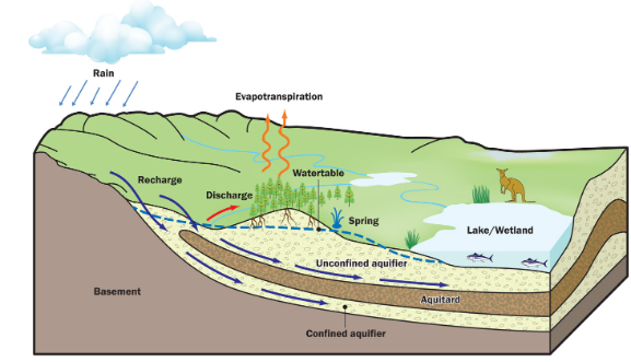
Groundwater is sub-surface water contained in the pores, cracks and fractures within the sediments and rocks. Surface water from rainfall or other water bodies percolates through the ground to the water table (recharge) where it is stored in aquifers (a layer of fractured rock, gravel, sand or limestone below the ground that is porous enough to hold groundwater, and allow it to flow). Groundwater moves laterally within and between aquifers with intervening aquitards retarding or restricting flow. Aquifers can discharge to the surface and are often important components of river flow and water for wetlands and native vegetation.
The Corangamite region contains a variety of deep and shallow groundwater aquifers of varying water quality and yield. Most of the Corangamite region is covered by the deep Otway sedimentary basin containing up to 700 metres thickness of sand and gravel aquifers interlayered by clay dominated aquitards overlying a deep bedrock. The basin is flanked to the south by the Otway Ranges covering Anglesea, Lorne, Forrest and Apollo Bay regions and to the north by the Great Dividing Range in the Ballarat, Meredith and Bunniyong regions. Both of these flanking areas contain shallow bedrock aquifers. More information on groundwater resources in the area can be found at:
- Visualising Victoria’s Groundwater data base provides information from groundwater bores across the state.
- Southern Rural Water’s (SRW) 2011 South West Victorian Groundwater Atlas provides a comprehensive overview of the location and depth of aquifers, groundwater management, limitations, and use in the Corangamite region.
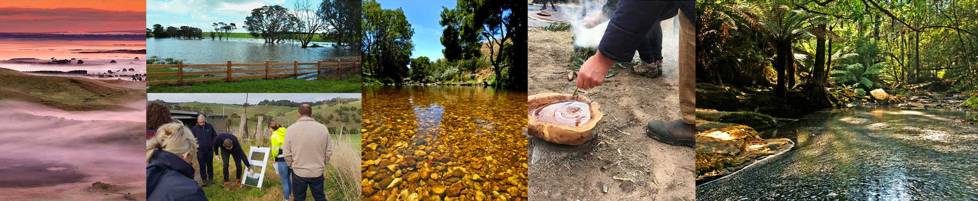
In the Corangamite region, groundwater is valued by the community and shared by many users. The Corangamite CMA region’s low stream flows and lack of topography suitable for dams has led to a high reliance on groundwater. Groundwater provides drinking water for many towns in the region (including Geelong, Ballarat, Bellarine Peninsula and Surf Coast). It is also drawn on for the supply of stock and domestic purposes, especially during low rainfall or drought periods. Therefore, the quality of this water is important for many rural asset managers across the Region.
The Corangamite region has many groundwater dependent ecosystems (GDEs), with groundwater playing an important role in the health of most wetlands and rivers. Groundwater discharge plays a key role in sustaining terrestrial vegetation communities, cave ecosystems and both terrestrial and aquatic fauna. There are two main types of groundwater dependent ecosystems in the region: 1) aquatic GDEs that rely on direct groundwater discharge such as wetlands, rivers and springs and 2) terrestrial GDEs that rely on vegetation drawing water from the watertable.
Groundwater resources in the Corangamite region are managed by Southern Rural Water, in line with the requirements of the Water Act 1989 and associated government policies. Southern Rural Water has delegated responsibility for licensing bore construction and the take and use of groundwater to groundwater diverters, and leads the development and implementation of groundwater management plans. Groundwater management plans take into account the potential impact of groundwater extraction on streams, springs, wetlands and other Groundwater Dependent Ecosystems. State policy and guidance on groundwater planning and licensing matters is provided by DELWP.
For major aquifers of the region, Groundwater Management Units are designated under the Water Act to ensure groundwater extraction remains sustainable. Each Groundwater Management Unit has a designated Permissible Consumptive Volume (PCV) which caps the volume of groundwater licence entitlement for uses such as irrigation and town water supply. The volume used for stock and domestic use is not counted as part of the PCV. In the Corangamite region, there are nine Groundwater Management Units covering the following aquifers:
- Cardigan and Bungaree GMUs – covering the shallow basalt aquifers in the Ballarat region
- Colongulac and Warrion GMUs – covering shallow basalt aquifers in the Colac and Camperdown regions
- Paaratte, Newlingrook, Gellibrand, Gerangamete and Jan Juc GMUs – covering the deep Dilwyn Formation and Eastern View Formation aquifers overlying bedrock in the Otway Basin stretching from Port Campbell in the west to Torquay in the east.
Assessment of current condition and trends
Groundwater is a finite resource and needs to be managed to ensure sustainable use. Data on groundwater levels show that after a period of decline, aquifers in Groundwater Management Areas in the Corangamite region recovered in the mid 2000s and are now stable. Exceptions to this generality due to groundwater pumping influences include:
- Cardigan GMU: during the millennium drought groundwater levels declined due to pumping by Central Highlands Water for Ballarat’s urban supply, however they have since recovered.
- Gerangamete GMU: groundwater levels are gradually recovering from three pumping cycles in the late 1980s, late 1990s and from 2006 to 2010 and 2016 when the Barwon Downs borefield was used as supply for Geelong.
- Gellibrand GMU: groundwater levels are mainly influenced by pumping by Wannon Water for supply to Warrnambool and other towns in the region.
- Jan Juc GMU: Groundwater levels were fairly stable before the 2000s, however there has been some decline since then due to increased reliance on this water for urban supply.
More information on groundwater level trends in the region can be found at Southern Rural Water’s Groundwater Hub. The Visualising Victoria’s Groundwater data base provides information from groundwater bores across the state. Southern Rural Water’s (SRW) 2011 South West Victorian Groundwater Atlas provides a comprehensive overview of the location and depth of aquifers, groundwater management, limitations, and use in the Corangamite region.
Major threats and drivers of change
Unsustainable groundwater extraction causing groundwater levels to fall has the potential to impact neighbouring users and groundwater dependent eco-systems such as river, wetlands and native vegetation. In an ever increasingly water-constrained environment, actual groundwater use is likely to increase as more of the currently unused portion of licences are used or traded. Combined with reduced recharge from climate change, such increased groundwater pumping is a potential risk to the health of groundwater dependent ecosystems such as rivers and wetlands.
Of particular interest in the Corangamite region is the demonstrated hydraulic connection between the deep aquifer tapped in the Barwon Water’s Barwon Downs borefield and flow in the Boundary Creek where the aquifer outcrops further south. The borefield was historically used to supplement Geelong’s water supply and was last used for a brief time in January 2016. Work commissioned by Barwon Water in 2017 confirmed that intermittent use of the Barwon Downs Borefield over the past 30 years – combined with the effects of a dry climate – led to a reduction in flows to Boundary Creek and the subsequent activation of acid sulfate soils in Big Swamp (the Yeodene peat swamp). Since major pumping ceased from the borefield, groundwater levels are recovering along with the impacts on connected groundwater dependent ecosystems. In March 2019 Barwon Water formally withdrew their application to renew the licence for Barwon Downs borefield to focus wholly on remediation of the environmental impacts of past groundwater pumping.
Other threats to groundwater resources and connected systems include:
- reduced groundwater recharge from urban development and large-scale revegetation or plantation establishment
- the potential for Acid Sulphate Soils to develop due to falling groundwater levels along lakes and the coast
- groundwater contamination from industry including landfills and inappropriate chemical use
- inappropriate fertiliser practices (wrong rate, timing or type) contributing to increased nutrients in groundwater
- climate change reducing groundwater recharge from rainfall
- replacement of native vegetation with crops and pastures (with or without irrigation) causing higher watertable levels resulting in land and water salinisation.