Landscape Systems
The Corangamite region is a large and diverse area ranging from Ballarat in the north to Geelong in the east to Camperdown in the west. The diversity of the landscapes, land use, climate and people across this area requires different management approaches to cope with this diversity.
Within these local areas consideration of important matters such as planning; land use change; landscape values; climate change; sustainable agriculture; water and land use planning; resilient and livable cities and towns; recreational use; demographic changes and so on need to be considered and where necessary, addressed.
To meet the needs of this diversity, nine sub-regional areas (landscape systems) have been identified and will provide the basis of localised, integrated action. A map of the Corangamite region’s Landscape Systems and links to all nine systems are provided below.
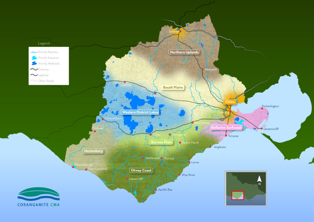
Corangamite Landscape Systems
Ballarat City
Barwon Plain
Basalt Plains
Bellarine and Surf Coast
Geelong City
Heytesbury
Northern Uplands
Otway Coast
Western District Lakes
An overview of the the various Landscape Systems and how they have been developed can be viewed by clicking here.
As outlined on the Home page, the Regional Catchment Strategy provides the framework for integrated management of the region’s natural resources. The Strategy itself does not include specific actions, but provides the basis for the development of on-ground actions that are guided by the Priority Directions for each landscape system. Landscape system based programs that involve all relevant partners and stakeholders provide the basis for on-ground coordinated projects that deliver the six year (life of strategy) outcomes and contribute to its longer term (20 year) aspirational outcomes. The process for implementing these is provided below.
Landscape System Implementation Planning
Landscape System based implementation plans will provide the basis of implementing the RCS up until the end of 2027. These plans will identify the actions that will deliver Regional Priority Directions that contribute to the delivery of the six year Outcomes for each theme. The priority directions for each landscape system have been developed through the following process:
- State-wide policy outcomes under the themes of Water, Biodiversity, Land, Coast & Marine and Communities provide the basis for Regional Outcomes.
- Regional Outcomes are both aspirational (20 year) and shorter term (6 year) with the six year outcomes contributing to the delivery of the 20 year outcomes. The six year outcomes are those that should be achieved across the life of this strategy.
- The six year outcomes for each of the five themes provide the basis for six year outcomes for each of the landscape systems. These provide the basis for the development of regional theme-based Priority Directions.
- Additional six year outcomes for each theme within each landscape system have been identified through community engagement.
- Priority Directions for landscape systems have been created by identifying all the relevant theme-based priority directions relevant to that landscape system and then consolidating them into a list of overall priority directions for that area.
Each of the priority directions has an identified lead and key collaborators who will contribute to the delivery of that particular priority direction through either direct action or by in-kind support. Other stakeholders will also contribute but will be captured under the relevant collaborator.
The process for implementation is outlined in the following diagram:
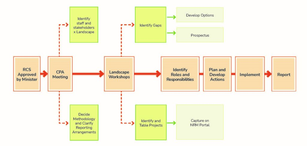
Delivery of on-ground actions will be reliant on appropriate resourcing; a key component of this process will be to identify available resources and any gaps. For this process to work, existing resourcing will need to be identified and captured spatially, with the preferred location for this being the NRM Portal. The NRM Portal provides details of past projects that have been delivered and can also be used to capture existing projects and project proposals.
The capture of current projects on the NRM Portal will allow project delivery as well as appropriate monitoring, evaluation and reporting of projects. The ability to capture project proposals also enables the linking of these to the RCS Prospectus section for prospective investors to view.