The Corangamite region provides a variety of options for prospective investors to resource projects that meet their various needs. The basis for this prospectus is to identify potential projects that are currently unfunded through existing programs. The Corangamite Regional Catchment Strategy renewal process and its associated on-going delivery plans identify where investment would enhance the delivery of the desired outcomes at a regional, landscape or property level.
An aim of this prospectus is to strengthen the role of the RCS as a conduit for substantial regional partner, Australian Government, private sector and philanthropic funding being secured for the integrated catchment priorities of the Corangamite region.
Investment Principles
This is the region’s fourth Regional Catchment Strategy (RCS), building on 20 years of achievements and lessons learnt and was renewed using the following principles:
- An integrated catchment management (ICM) approach.
- Regional ownership – embracing the regional delivery model, including co-delivery from committed partners.
- Blending of a systems approach with asset based approach that enables the management at a local scale through the use of systems, while assessing assets and their management contribution to policy and strategies at a regional scale.
- Built on strong community engagement and stakeholders partnerships.
- Regard for Aboriginal cultural values and traditional ecological knowledge.
- Triple bottom line approach considering socio-cultural, economic and environmental factors.
- Evidence-based, supported by best available information via science and defendable data sources as well as application of relevant planning, implementation and delivery systems
When making decisions on how best to invest in projects that will contribute to the RCS the following principles will guide the decision-making process:
- Contribution to the RCS outcomes – the work to be undertaken can demonstrate how it will contribute to RCS outcomes.
- Public benefit –activities are considered to provide a significant public outcome, which would not occur otherwise
- Efficiency – targets activities for maximum return on investment and encourage projects to leverage other sources of funding to capitalise on opportunities and strengthen community buy-in.
- Collaboration –promotes effective collaboration between landholders, communities, traditional owners, delivery partners, stakeholders, and agencies, to harness their knowledge and energy
- Integration – has the potential to integrate natural resource management planning and delivery across Landscape Systems, issues, industry sectors and government agencies, to provide community and environmental benefits.
- Adaptive management – builds upon past success, along with opportunities for learning and informing processes that support future investment decisions.
- Regional coordination/delivery – organises project delivery at the regional scale to ensure effective regional level outcomes that contribute to state-wide outcomes.
- Accountability – can clearly demonstrate management systems, governance models and ethical practices
The following table lists proposed projects seeking funding within the Corangamite region.
| Project name | Proponent | Theme(s) | Description | Landscape System | Full Details | Link to map | |||||
| 1 | Seeding the Victorian Volcanic Plains | Corangamite Catchment Management Authority | Biodiversity | 2-part private land stewardship program building on the strengths of GEW Stewardship Program (2020-2023) and establishing a new Natural Temperate Grasslands and Seasonal Herbaceous Wetlands Stewardship Program. | Basalt Plains | Link to description | view on map | ||||
| 2 | Increasing ecological services at Serendip, You Yangs and the Brisbane Ranges. | Department of Energy, Environment and Climate Action. | Biodiversity | Improve the value of low biodiversity function plantings by significantly modifying the native plantations to reflect appropriate Ecological Vegetation Class structures, species compositions and adding wildlife corridors. | Basalt Plains | view on map | |||||
| 3 | Linear Reserve Program – Extension | Corangamite Catchment Management Authority | Biodiversity | Continue Linear Reserves partnership to protect critically endangered species of the Victorian Volcanic Plains on roadsides, rail reserves and cemeteries. | Basalt Plains | Link to description | view on map | ||||
| 4 | Protecting Yarra Pygmy Perch and Growling Grass Frog Habitat – East | Corangamite Catchment Management Authority | Biodiversity | Fence and revegetate sections of the Victorian Volcanic Plain / waterway interface to protect Yarra Pygmy Perch and Growling Grass Frog habitat. | Basalt Plains | view on map | |||||
| 5 | Protecting Yarra Pygmy Perch and Growling Grass Frog Habitat – West | Corangamite Catchment Management Authority | Biodiversity | Protecting known habitat of Yarra Pygmy Perch and Growling Grass Frog and threatened grassland communities | Basalt Plains | view on map | |||||
| 6 | Corangamite Fishway Program – Barwon/Moorabool | Corangamite Catchment Management Authority | Water Biodiversity | Instream barrier prioritisation for stream connectivity | Barwon Plain, Geelong City, Basalt Plains | view on map | |||||
| 7 | Sparrovale Revegetation Phase 2a | City of Greater Geelong | Biodiversity | Revegetating grassy woodland EVC | Bellarine & Surf Coast | view on map | |||||
| 8 | Sparrovale Revegetation Phase 2b | City of Greater Geelong | Biodiversity | Revegetating old fill site with native grasses | Bellarine & Surf Coast | view on map | |||||
| 9 | Barwon River Estuary – A Journey Through the Landscape | Barwon Coast Committee of Management | Community | Will engage and strengthen understanding on cultural and environmental values and impacts in the Lower Barwon Estuary | Bellarine & Surf Coast | view on map | |||||
| 10 | Lovers Walk Weeding | Bellarine Catchment Network | Biodiversity | Weeding along the west of Lovers Walk | Bellarine & Surf Coast | view on map | |||||
| 11 | Lower Barwon Wetlands – Flows Study Update for Reedy Lake & Hospital Swamps | Corangamite Catchment Management Authority | Water | Updating the 2012 water regime recommendations for Reedy Lake & Hospital Swamps with the benefit of more recent data, including a completed Water Salt Balance Model | Bellarine & Surf Coast | view on map | |||||
| 12 | Barwon Through Geelong Instream Hazard Removal Program | Corangamite Catchment Management Authority | Water | A coordinated hazard removal program is required in partnership with Victoria Police to remove the 27 cars, 1 speed boat and 1 shipping container recently mapped in the Barwon Through Geelong. | Geelong City | view on map | |||||
| 13 | BioLinks for Brush Tail Phascogale | Parks Victoria | Biodiversity | Biolinks for Brush Tail Phascogales will target the Rowsley / Parwan Creek area, from the Brisbane Ranges National Park through to the Werribee Gorge State Park (Ingliston Block), enhancing and establishing habitat for Brush-tailed Phascogales to traverse through. | Northern Uplands | view on map | |||||
| 14 | Central Highlands Water | Water | The project establishes buffers to waterways that provide environmental, social and economic values to our community. | Northern Uplands | view on map | ||||||
| 15 | Central Highlands Water Revegetation Opportunities | Central Highlands Water | Biodiversity | Potential Revegetation Project sites | Northern Uplands | view on map | |||||
| 16 | Buninyong Biolink | Department of Energy, Environment and Climate Action | Biodiversity | Reconnecting the Wombat and Enfield forests and improving ecological values and resilience to climate change and wildfire. | Northern Uplands | view on map | |||||
| 17 | Central Highlands – Restoration and protection of biodiversity. | Department of Energy, Environment and Climate Action | Biodiversity | Protection of priority reserves from pest animals and weeds that impact on vulnerable vegetation and threatened species. | Northern Uplands | view on map | |||||
| 18 | Connecting the Dots – Buloke Protection | Department of Energy, Environment and Climate Action | Biodiversity | Engage with landholders and provide incentives to improve knowledge and map and protect remnant stands of Bulokes. | Northern Uplands | view on map | |||||
| 19 | River Enhancement – Upper Moorabool | Corangamite Catchment Management Authority | Water Biodiversity | Partnership with Barwon Water to remove willows, hawthorn and revegetate along waterway from Bolwarrah Weir to State Park. | Northern Uplands | view on map | |||||
| 20 | Coastal Woody Weed and Habitat Control | Department of Energy, Environment and Climate Action | Biodiversity | This project aims to halt the degradation of high value habitat across the Otway Ranges focusing on the 2km wide strip of coastline. This includes the iconic Anglesea Heath and coastal cliff tops of Port Campbell and Cape Otway. | Otway Coast | view on map | |||||
| 21 | Connecting Otways Country- Feasibility study for reintroduction of New Holland Mouse to the Otways | Corangamite Catchment Management Authority | Biodiversity | Desktop studies and ground truthing will identify suitable habitat for Pookila throughout the Otways and provide guidance to land managers of threatening processing and works required for habitat protection and improvement. | Otway Coast | view on map | |||||
| 22 | Stony Rises Wetlands | Corangamite Catchment Management Authority | Water | A wetland tender program that targets wetlands listed as ‘Wetlands of National Importance’ within the Stony Rises. | Western District Lakes | view on map | |||||
| 23 | Stony Lakes | Corangamite Catchment Management Authority | Biodiversity | Protecting stoney rise habitats of Corangamite Water Skink, Growling Grass Frog, Fat-tailed Dunnart and threatened plant species | Western District Lakes | view on map | |||||
| 24 | Wandering for the Plains-wanderer | Corangamite Catchment Management Authority | Biodiversity | Support on-ground monitoring work and habitat protection across the Victorian Volcanic Plains targeted at the Plains-wanderer. | Basalt Plains | Link to full description | |||||
| 25 | Linear Reserves Weed Control | Corangamite Catchment Management Authority | Biodiversity | Continue weed control along linear reserves to protect critically endangered GEW and NTG of the Victorian Volcanic Plains on roadsides, rail reserves and cemeteries. | Basalt Plains | Link to full description | |||||
| 26 | Barwon River Loop Trail | City of Greater Geelong | Water | Development of a shared trail linking existing trails in Mt Brandon area on south side of Barwon River with northern trails in the Papermill area including a pedestrian bridge across the Barwon River adjacent to the Geelong Ring Road | Geelong City | link to map | |||||
| 27 | Moorabool River Reserve (Golden Plains Shire) | Golden Plains Shire | Water Biodiversity Community | Implement the Golden Plains Shire Moorabool River Reserve Masterplan establishing new seating, picnic and nature based play facilities consistent with natural floodplain and Wadawurrung values. | Geelong City | link to map | |||||
| 28 | Sheepwash Boardwalk | Parks Victoria | Water Biodiversity Community | Boardwalk and fishing platforms along the mangrove dominated southern bank of the Barwon River on the north-western edge of Barwon Heads township. | Bellarine and Surf Coast | link to map | |||||
| 29 | Implementation of Barwon Coast Caravan and Camping Park Masterplan at Bukareeyoo (Ocean Grove Spit) | Barwon Coast Committee of Management | Water Biodiversity Community | Support renewal of visitor and camping infrastructure including connecting public toilet blocks to reticulated sewerage to ensure protection of cultual and environmenta values of the area and water quality of the Barwon River | Bellarine and Surf Coast | link to map | |||||
| 30 | Waurn Ponds Creek trail connection to Barwon River Trails and re-vegetation | City of Greater Geelong | Water Biodiversity Community | Extend the Waurn Ponds Creek shared path through the South Barwon Reserve to link to the Barwon River Trail at Gundog Lane. Re-establish native riparian vegetation along river corridor including Deakin University managed land | Geelong City | link to map | |||||
| 31 | Gundog Lane Barwon River Access | City of Greater Geelong | Water Biodiversity Community | Extend the Waurn Ponds Creek shared path through the South Barwon Reserve to link to the Barwon River Trail at Gundog Lane. Re-establish native riparian vegetation along river corridor including Deakin University managed land | Geelong City | link to map | |||||
| 32 | Porronggitj Karrong | Barwon Water | Water Biodiversity Community | A partnership with Wadawurrung Traditional Owner Aboriginal Corporation to develop the Porronggitj Karong site into a publicly accessible, shared community space, fostering connections with the Barwon River and broader Country | Geelong City | link to map | |||||
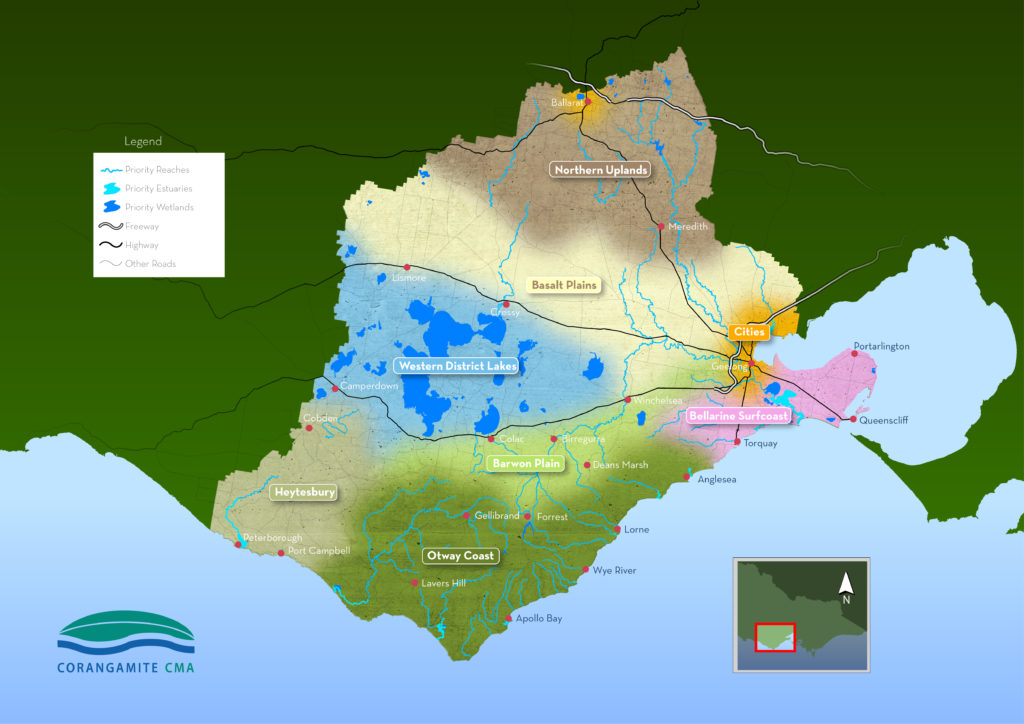
The following map outlines the Landscape Systems of the Corangamite region.
The following tabs provide access to where project proposals can be viewed spatially by prospective investors.
The following link provides the user with a spatial view of prospective projects for the entire Corangamite Region
Ballarat City Landscape System
The following link takes the reader to the NRM Portal where prospective projects for the Ballarat City Landscape System can be viewed spatially.
Barwon Plain Landscape System
The following link takes the reader to the NRM Portal where prospective projects for the Barwon Plain can be viewed spatially.
Basalt Plains Landscape System
The following link takes the reader to the NRM Portal where prospective projects for the Basalt Plains can be viewed spatially.
Bellarine and Surf Coast Landscape System
The following link takes the reader to the NRM Portal where prospective projects for the Bellarine and Surf Coast can be viewed spatially.
Geelong City Landscape System
The following link takes the reader to the NRM Portal where prospective projects for the Geelong City Landscape System can be viewed spatially.
Heytesbury Landscape System
The following link takes the reader to the NRM Portal where prospective projects for the Heytesbury can be viewed spatially.
Northern Uplands Landscape System
This link takes the reader to the NRM Portal where prospective projects for the Northern Uplands can be viewed spatially.
Otway Coast Landscape System
The following link takes the reader to the NRM Portal where prospective projects for the Otway Coast can be viewed spatially.
Western District Lakes Landscape System
The following link takes the reader to the NRM Portal where prospective projects for the Western District Lakes can be viewed spatially.